Friday, June 28, 2013

6/27 Trip to Crested Butte

To get to Lakeview campground near the Taylor Reservoir means leaving the main highway and driving 15 miles through an open valley filled with ranches, a narrow canyon along a river, and finally to the wide valley of the reservoir with the high mountains not too far away.  The paved road ends just down the road, but you can go over a couple of passes on dirt roads if you choose.  (I don't!)

However, today I decided to go out to visit the nearby town of Crested Butte.  Crested Butte is a small resort town about 30 miles from here.  Getting there means driving back out of the valley to the main road and then heading north.  The reservoir was very calm this morning when I left, so the mountains in the distance make a pretty reflection.


Here is the wider valley of the main road.
 
And here is the  town itself.  Very pretty place with some interesting shops.  This week is a special mountain bike week, with multiple races and events. 


And just one of the incredible mountains near the town.

Heading back to the campground, I noticed some cowboys on horses and cows in the woods alongside the road.  Apparently, around here, they move the cows around from pasture to pasture depending on the time of year.  About a mile farther along, I ran into an unsupervised herd that was walking on the road. They really had no place else to go since the mountain was steep on one side and the river was on the other side.

At first, I tried to move into the left lane to pass them, like the car in the photo above.  I then saw other cars approaching in the distance, so I moved back into my own lane and followed the animals at cow-speed, which is very slow.  Yellow center lines apparently do not mean much to them.


I finally let another car pass me and decided to follow close on their bumper.  In this last photo, you can see that the cows in the lead had found a place where they could head up into the woods along a less steep slope.  It took about a mile of this parade to get past the herd.

I will have to admit that it was cute to see each calf working to keep up with its mom.

They are building a chain link fence with barbed wire on top of it around this campground because of problems in the past with cows and even a bull wandering through the campsites.  It will not be done for a few weeks, however.


Wednesday, June 26, 2013

6/25 Colorado Alpine Wildflowers

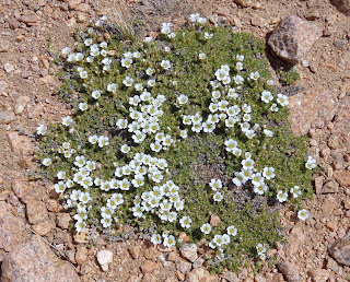
This has taken me quite a while to identify these flowers, but here are some photos I took of on top of Monarch Pass, east of Gunnison, Colorado, at over 12,000 feet.  These are very short, cushion-type plants that live in clumps because it protects them from the wind and cold:

The first is Moss Campion, which comes in several colors.  These were white and purple.


This next is called Diapensia or Cushion Plant. It looks a lot like Moss Campion, but the petals are more rounded and cupped.
 
Next are two yellow flowers.  The first is Alpine Buttercup and the second is Western Wallflower:
 

This one has me stumped.  I am going to go to a bookstore tomorrow and find a better wildflower book.  If anyone knows what this one is, I would appreciate knowing.  The petals are purple and white, and clumped into clusters.  Height is about 6-7".

And finally, here is some Lupine I found in the Lakeview Campground at 8,500 feet.  It is much taller since it does not have to fight the wind:

At least this is a good start at learning plant names.  I will be adding more as I photograph and identify them.
 

Monday, June 24, 2013

6/24 Colorado Springs to Lakeview Campground

I left early this morning, after making sure my waste tanks were empty and my fresh water tank was full.  I stopped in Canon City at a Walmart for groceries because I knew that there was nothing within 40 miles of where I was headed--Lakeview Campground along Taylor Reservoir in the Gunnison National Forest.

For quite a while, U.S. 50 went along the fast-moving Arkansas river. I kept seeing signs about watching out for smoke and poor visibility, but everything was clear, so the fires must be under control.  Wish there had been a place to pull over.  Unfortunately, most pullovers are made for cars and my motorhome just does not fit!


As I drove the mountains got more rocky and the road higher, heading for Monarch pass.  There was a gift shop at the top and a gondola ride to the top of the mountain at 12,000 feet.  Windy and cold up there but incredible views.


Views from the top:


I took quite a few photos of alpine flowers, but I have to identify them before I post them.

Onward through Gunnison to Taylor Reservoir.  The road went through a very pretty green valley to the town of Almont, and then on a dirt detour. 


The dirt detour was really in pretty good condition.


And finally the campground.

6/23 Cheyenne Mountain State Park, Colorado Springs

Stayed at Cheyenne Mountain State Park.  This is a fairly new state park just below Cheyenne Mountain, which is that used-to-be-top-secret strategic command center buried in a mountain that is supposed to survive a nuclear attack.  From the campground, you have a good view of the mountain and a good view of Colorado Springs below.  Nice campsites with cement pads and full hookups.


Heading tomorrow to visit my cousin and his wife at a campground near Taylor Lake, which is in Gunnison National Forest.

Saturday, June 22, 2013

6/22 From Kansas to Colorado Springs

Had a very long day today, driving 333 miles.  That may not sound like a lot, but it is a lot when you have to wrestle a big vehicle that is sensitive to side winds and pavement which dips and is uneven.  I took the long loop around the reservoir I had been staying at and took these pictures of an old school and a country church.


My GPS has been giving me problems by freezing or dying just when I need it to make a turn.  I have been turning if on only when I absolutely need it and trying to memorize the turns and directions in case it died.  Today, it told me to get off the freeway, or at least I think it did, and turn south for 35 miles.  Then it said to turn west for another 100 miles, and finally it said to go back north to the freeway which was another 35 miles!  Did not make sense.

I looked at a real map and saw a much more direct route to Colorado Springs--Route 94.  I stopped and asked at a small museum and was told it was fine but to make sure I got gas ahead of time because there was nothing for 70 of the 93 miles of this road.  I used two cards and filled it up.

Anyway, it was straight as an arrow, and of course, absolutely no gas stations, restaurants, or even stores along the 70 mile stretch.  I took several photos showing how desolate this area is and how straight the road is.


Long drive, but beautiful in a lot of ways.  It was a hazy day, but in the last few miles, I finally got my first look at the front range of the Rocky Mountains.  Yea!!  Tonight I stay in a lousy KOA, but tomorrow I get a haircut, run some errands, and stay at Cheyenne Mountain State Park, which is high above Colorado Springs and looks beautiful from the pictures on the web site.  I would have liked to stay there tonight, but it was packed because of the weekend.  I need to do a better job of planning for weekends because I really need reservations long in advance for Friday and Saturday nights.

Needed to add the photo I took of my first view of the Rocky Mountains!

Wednesday, June 19, 2013

6/19 Cedar Bluffs State Park, KS

After two hard days of driving, I knew when I planned this trip that I would need some downtime, so I found this state park not too far off of I70.  Had a rough arrival last night after driving 325 miles, with the last 25 through a horrible hail and windstorm.  Rain and hail was so bad, traffic slowed almost to a stop and the motorhome did a lot of rocking.  I slowly found my way off the expressway onto an exit ramp where I parked until it let up. 

The country in Eastern Kansas looks a lot like the Midwest farm country, but as I drove, it changed to this more prairie-looking scenery.

Got off the interstate soon after the rain ended, and made my way down a very pleasant country road, where I had to stop and take a photo of this old house.


Before it got too hot this morning, I took a long bike ride around the campground and then onto a gravel road on top of the dam. Here are some views from the long dam road.


Most of the dam is earth and rock, but there is this spillway at the far end.  Not enough water to worry about any spilling over right now, however.


There was absolutely no traffic so I decided to ride back to the campground on the regular highway.  Nothing passed me on the mile or so back. 

The campground is mostly deserted because this is a weekday, and the weekend boaters and fishers have not arrived.  That's fine because I like the quiet.

I am going to leave here early Friday morning and head to another reservoir closer to Colorado Springs so I do not have such a long drive on Sunday to get to Cheyenne Mountain State Park.