Thursday, November 28, 2013

11/27 Palm Canyon Trail

This is a very popular 3-mile trail that goes from the campground, up Palm Canyon, to a desert oasis and palm grove that gives the canyon its name.  It is supposed to take about 2.5 hours to hike this, but it took me a whole 5 hours because of having to climb over so many rocks with my sore knees.  This first photo shows the first part of the hike.  The "trail" is the rock-strew path on the right.

This is looking back down the trail to the valley.  You can barely see the campground in the distance.

The native American's also used this area, and this is one of the holes they used to grind seeds.

Believe it or not, the trail goes just to the right of this creosote bush.  Luckily the rocks seemed pretty stable.  I had worn my new shoes which have good rubber soles and did not slip too much.

Can you find the trail here?

About halfway up, you first see the little creek coming out of the spring.  Amazing to see water in such a dry desert.
 
Here is the first view of the oasis at the end of the canyon. These are native California palms, with thicker trunks and getting up to 60' tall.

This is looking back down the canyon where I walked.

Apparently someone has put down some steps.  Makes it a lot easier, but would be even easier if they were more even.

Getting closer to the oasis.

And the trail really does go between those two big rocks.  Have to really scramble to get through this rock pile. I went very slowly so as not to fall or turn an ankle.

And the red marker on the bush tells you the trail goes to the left, over the rocks.  Would not know that were it not for the marker.  Saw a couple of dads carrying small children over these.

Mature palm trees at the oasis.

You can see the waterfall between the big boulders on the right. This is what provides the water for the oasis.

It is dark and damp inside the trees.  Hard to walk but the trail ends here.  I suppose if you are very athletic, you can go farther.

These trees were so tall it was hard to get them all in the photo.  Very impressive.

I chatted with several older couples along the trail.  One couple had been here many times and recommended the "alternate" trail on the last half of the downward hike because it had fewer rocks to climb.  They lied.

And more rocks to walk through.  I was really tired by this point and my knee muscles kept going into spasms.  I kept my eyes on the trail because I did NOT want to fall.

Yup, trail goes right over these rocks.  There were dozens and dozens of places where I had to get down and practically crawl over these.  About 2/3 of the way down, I slid and ended up sitting on my read in a bush which had a cactus in the middle of it!  One of the couples I had met earlier, but NOT the one who had told me this trail was easier, found me sitting in the bush.  The man helped pull me up and his wife kindly helped remove the spines stuck in the rear of my shorts.  They were Australian, and she suggested I take off my "knickers" when I got home and use tape to get the rest out.

We did find a large flock of quail, and I managed to sneak a picture in before they scurried away. I later looked them up and discovered they are probably California uail, not Gambel's quail.  They have very close ranges, but they do not overlap. This area is right on the edge.
 
So, after five hours of walking and rock climbing, I made it back to my RV.  I took off my clothing before I sat down, used some duct tape to remove the last of the spines, and took a shower.  It felt wonderful.  Even though the hike was a LOT more strenuous than I had expected, I was really glad I had seen this very unusual place.  Next time, I am going to take a flashlight, however, just in case I got injured.  The sun sets fast this time of year, especially with the mountains, and although there were other people on these trails, a flashlight would have helped me get out or let someone find me more easily. 

Wednesday, November 27, 2013

11/25 Drive Around Salton Sea

The Salton Sea is only about 40 miles from Borrego Springs, so I decided to make a day trip and circle around it.  Weather is sunny and temps are in low 70s, so why not?  First, Borrego Springs is a strange town--the GPS shows tons of roads and residential streets, but in reality there are very few stores and almost no homes on all those streets.  Apparently, a lot of developers were very optimistic.

(Could be the 110 degree summertime temperatures have something to do with the lack of residents.)  Nice, wide streets, however, with good bike lanes.

The road from Borrego Springs to Salton is California 22.  As soon as you get out of town and past the state park land, there are hundreds of little clumps of people dry-camping in the desert.  No one seems to care, and a lot of these campers bring motorcycles, 4-wheelers, or dune buggies along with them to take advantage of the many mountain paths and semi-roads. 


After getting some cheap gas, I headed to the southern end of the sea.  The whole bottom end is part of a National Wildlife Refuge, named after Sonny Bono for some reason.  Not much of it is accessible by car, and a lot of this area is agricultural, strangely.

Found this little desert bunny hunkered down along the sidewalk.  He did not mind his photo being taken.

This field is owned by the refuge.  The next photo will show the huge flock of snow geese that were visiting that day.  You can identify them even from a distance because of their black wing tips.

I had been a little upset to see several of what I thought were chemical plants, but was told these were geothermal energy plants.  Apparently, the Salton Sea is directly on the San Andreas Fault, so they take advantage of the earth's heat to produce electricity.  There have been some studies showing that the water pumped in and out causes earthquakes.


There are mountains in the distance, but this area on the east side of the sea is pretty desolate.
 
And there actually are beaches along the Salton Sea!  This one was at Mecca Campground, which is part of the Salton Sea State Recreation area.


There are a lot of dead fish on the beach, and I am not sure I would want to swim here, but the area is full of sea birds.  There is a very interesting campground with full hookups, and I thought it was nice enough that I am moving there on Thanksgiving because it seemed such an interesting place.  More later!
 
Got back to the campground at Borrego Springs after dark and had a rough time getting onto my leveling blocks in the dark, but luckily I have a pull-through site, so at least I did not have to back in.


Tuesday, November 26, 2013

11/24 Anza-Borrego Desert Plants

From a distance, the desert looks beautiful, but mostly dead. 


A lot of the shrubs and plants look dead also.  Here is one, I can't identify right now, but if you look closely you will see a few leaves and some red flowers.  Not dead at all.  Just waiting for rain.

The most common bush in this desert is the creosote bush.  It smells like creosote when you touch its glossy leaves. The waxy coating on the tiny leaves keeps the moisture from evaporating.


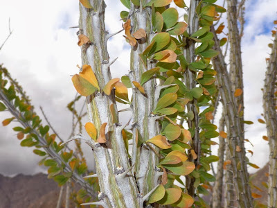
To conserve moisture, a lot of plants have very small leaves or no leaves at all.  Here is an ocotillo which looks dead from a distance, but when you get up close, you find leaves directly on the stems.


This one is called a burro bush, and it has very small leaves.

And the paloverde bush has no leaves at all.  It has green stems which perform photosynthesis in place of leaves.
 
 
Cactus also have no leaves, and most have thorns to keep animals from eating the fleshy parts where they store water.  Here is a barrel cactus and another with fruit. 

 
 And two kinds of cholla.  The first is a Ganders cholla and the second is a diamond cholla.  Both look very sharp! 


There is another, fuzzy-looking cholla called the teddy bear cholla that I have personal experience with.  It looked so soft, I touched it and had to use duck tape to get all the fine spines out of my finger.  Ouch!

Did you know California has a native palm?  It is called the California Fan Palm or Washingtonia Filifera.  You can identify it by the thick trunks.  There is fossil evidence in Anza-Borrego desert that this palm has been here for 5 million years!  These below are wild and were not planted. 


Friday, November 22, 2013

11/22 Planning My Travels

Someone recently asked me how I plan my travels.  That’s a very good question.  Here is my answer:
  1. I start out with a very general idea of where I want to be at a particular time of the year.  For example, right now I know I want to be in Las Vegas by mid-December at the latest.  I am planning to fly to Ohio after Christmas, so I planned around that.  In addition, I want to spend most of January and February in Arizona, and be in New Mexico for March.  April will probably be Texas as I work my way back to Michigan and Ohio.
  2. Next, I do a lot of online research to decide what places I really want to visit.  I had heard that this state park I am in right now was very beautiful.  Another place that was a must was Death Valley since it has been 50 years since I have been there. I also had gotten a recommendation not to miss Valley of Fire State Park north of Las Vegas. 
  3. I don’t like to drive more than 225 miles each day, and I don’t like to drive every day, so I start plotting a route using Google Maps that will get me to the places I want to go. I may adjust it several times.
  4. I like to stay in state or national parks, but I also like to have an electric hookup so I can watch satellite TV.  I also need cell service for my mobile hotspot so I can have internet access.  So, I start looking for state or national parks along my route to see what is interesting and what campgrounds are available. I also like a view, if possible.  I tend to be really picky about where I stay, so I spend a lot of time on this.  I also consult rvparksreview.com and use Google maps to actually look at the campground and what is nearby.  The maps help me pick out the best site, also.
  5. Also, since gas is a major expense when you are only getting 8-10 MPG, I try to plot out routes that don’t require a lot of backtracking and will get me where I want to go in a logical order. 
  6. Using an Excel spreadsheet, I start to fill in the blanks.  I have columns for dates, arrival location, departure location, number of miles, name of campground, costs, notes, etc. for each date. If I drive one day, I try to stay in the next place for at least two nights.     
  7. When I get all the blanks filled in and am comfortable with that leg of my trip, I go online and make reservations.  A lot of people just drive and take their chances, but I am fussy and feel much more comfortable if I have things planned out. 
A lot of times, I find real gems along the road, so some of it is just pure luck.  I am always keeping my eye out as I drive for places I want to come back to. 

I have some very long-term plans to spend next summer in Colorado, and then Montana, Idaho, Washington, and Oregon.  After that I might head to Florida for the 2014-15 winter.  Someday I want to visit New England, but don't see where I can fit it in right now. 

Thursday, November 21, 2013

11/21 More Desert & Some Sculptures

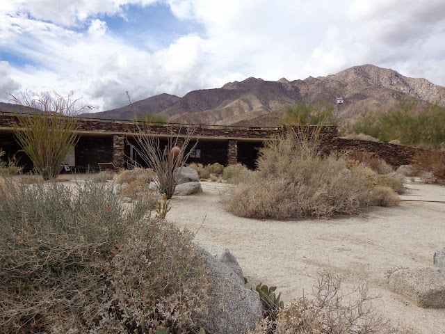
Loving the scenery around here!  Here are some photos taken around the visitor center. It has been threatening rain all day, but no drops yet.


After some lunch at home, I headed out on my bike through Borrego Springs.  This is the center of this pretty empty town.

This is what I was heading for.  These metal sculptures are by artist Ricardo Breceda.  Here is his website:  http://www.ricardoabreceda.com/


I liked this sea serpent!  You can see how large it is. 

Here is the sea serpent's head.

And across the highway is his tail!  Looks like a rattle on the end.


The previous photos were of sculptures that are several miles out of town.  The next two are in the town sculpture park.  There were more, but I did not bother taking photos of all of them.

 
Barely made it back home because I had to ride 14 miles round trip to take these photos, so my battery is now charging.