Tuesday, July 29, 2014

7/29 Mount Rainier National Park

A lot of days I am either driving through dull areas or sitting in my motorhome working or relaxing.  Today I drove to Mount Rainier and spent most of the day getting to the highest visitor center and then driving back home.

I love this park entrance!  All national parks should have such an impressive "doorway"!

A few miles in, I drove across a bridge and saw this, so I pulled over and walked back. This river is at least 25' feet wide, so distances are deceiving.  Can you imagine how many mud flows and floods have occurred here over the eons?  

This is a close-up.  Can you see the waterfalls?  One is fairly close and on the left.  The other is a little to the right of the middle and in the far distance about a third of the way from the top of the photo.  Wow!

This is the view down-river, from the opposite side of the bridge. 

There was a small sign pointing the way to an overlook.  Terrific view!  There were quite a few climbers on the snowfield just behind and to the left of the tall tree on the right.

Hard to see, but each little dot is a person climbing or walking on the snowfield. 

Just a nice view of a valley and river.

This is the top of Christine Falls.  The next photo shows the bottom and the rainbow. It was a steep and slippery walk down the path to the lower viewing platform, and I was not wearing good shoes or carrying my hiking pole, but I made it without falling.


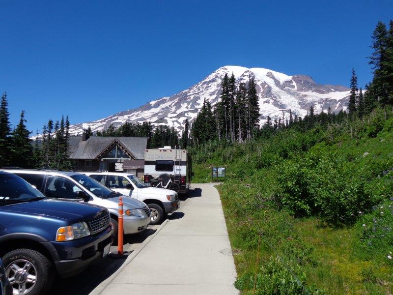
I did not take many photos of the visitor center because I had already taken a lot of the mountain.  Parking was very tight, but I managed to find a place a long walk away.  This was some sort of service building, not the visitor center.  

This is a view of that bridge I had stopped at on the way up and the stream that flowed under it.

 
A lot of really big trees to drive through. This part of the road was very narrow, but luckily one-way.  

Nice to get home!  My upper arms and shoulders were very sore from wresting the steering wheel.  My vehicle is not that hard to drive on flat ground, but when you have to be constantly steering, it can get tiring. 

Saturday, July 26, 2014

7/25 Palouse Falls, WA

I drove east from Clarkston and the Snake River today, with a stop at Palouse Falls, WA.  This part of Washington is nothing but rolling hills of wheat and grasslands.  The road followed the Snake River for just a few miles, but it was impressive anyway.


The endless hills and "fields of grain" reminded me of America the Beautiful, but it looks also slightly like a kind of desert.


After about 70 miles, the back road I was driving on dipped down into a valley where the Snake River came into sight again.  There was a railroad track to the left and this very impressive trestle across the river for another track.  Believe it or not, out in the middle of nowhere, there was a KOA campground on the river near the marina.

This photo does not do it justice, but the height of the railroad trestle was really impressive.

Doesn't this look like an endless desert? 

Finally arrived at one of the smallest state parks I have ever been to.  But at the end of a very dusty dirt road, there was a parking lot with a short walk to these falls.  The very strange geology is the result of cracks in volcanic lava flows and the many floods produced by the emptying of Lake Missoula. 

Lake Missoula was a huge lake north of here that was produced by melting glacial ice during the ice ages.  The lake was blocked by huge ice blocks that broke loose resulting in floods hundreds of feet deep traveling at up to 60 MPH.  This widened the cracks and created some very strange looking country.  Very nice falls, in any case.


 This shows the downstream river where the falls emptied.

And the railroad trestle again.

I enjoy old bridges like this one, but was glad there was no traffic, as it was very narrow for my wide vehicle.


My GPS took me along a very deserted country road on the way to my next campground.  You can see the lack of traffic on this route--just how I like it!!

Now this is where it got weird.  I ran across several of these grain elevators.  If you look closely, you will see that it looks as if the road originally went right through the elevator and under the grain chute.  They apparently built the newer road around it. 

Ditto for this one.

I just love to take photos of these empty long roads that go into the distance without stopping.

All in all, this was a great side trip and MUCH better than sticking to the main highway or a freeway. 

Thursday, July 24, 2014

7/24 Clarkston, WA, Bike Trail

I chose this campground for a couple of night stay because it is right on the Snake River, just across the Idaho border.  It is also a very pleasant campground, with paved sites, nice landscaping, and full hookups, although I seldom really use full hookups.  Most importantly, I had a pull-in site with a terrific view right next to the bike trail.  I haven't ridden my electric bike in quite a while so it was nice to get out on such a beautiful day, although getting it uncovered and the tires filled up with air is a chore.

The bad thing is that in spite of the cover, it was filthy underneath.  Must have at least partly been the dust storm I drove through in Wyoming, but I am sure just ordinary road dust did not help.  Cover and bike were dirty and the accelerator still sticks so I used damp paper towels on the bike and some WD40 on the accelerator control. (It sticks on, so that when I stop my bike, it wants to take off on its own.  Not very safe or fun.)

Yesterday, I drove along the Clearwater River, coming from the east through Idaho.  Just a few feet upstream from the campsite  (and at the Idaho/Washington border) is where it combines with the Snake River


This car bridge is on the Snake River.  Bit scary riding over it because there was no bike trail, which is strange because there are bike trails on both sides for several miles along both the Snake and the Clearwater.

This sculpture is in Idaho on a building near the bridge above.

This was a memorial to Lewis and Clark along the trail.  In the front, you can see a bronze sculpture of Sacajawea with waves of water behind her.

On the waves behind Sacajawea are reliefs of many of the animals in the region. 


This monument says that Lewis and Clark camped here on October 10, 1805. 

More of the Idaho shore of the Clearwater River.

I rode down about 4 miles, turned around, and then followed the Idaho side of the Snake River all the way to Hell's Gate State Park Visitor Center.  Hell's Gate is a narrow canyon on the Snake River with wild rapids.  You can take a jet boat tour of the rapids, but I am pretty much a coward when it comes to rapids., so that was not on my agenda.   

You can see what an excellent bike trail this is.  Both sides of the Snake River and one side of the Clearwater River have parks along them.  Very pleasant.


Back to the campground.  Took some photos from the bike trail.

Here is my vehicle, second from the right. 

They allow you to wash vehicles in this campground, but mine wasn't dirty, but I did get out and scrub my bike cover.  I just hate taking it on and off when it is so dusty and grungy.  I have to wash my hands and arms, and it also leaves dirt on my clothing.  I am supposed to keep my bike covered because the electrical components should not get rained on.  No rain for the next few days, so may just fold the clean cover up and stuff it in a compartment underneath. 

7/23 U.S. 12 - Lolo Scenic Trail

Today's drive was 225 miles from Missoula, MT, along U.S. 12 through the Clearwater National Forest.  This was the trail taken by Lewis and Clark.  It starts out over the Lolo Pass and along the Lochsa River.  This river joins the Selway River and then becomes the Middle Fork of the Clearwater River. 

Lewis and Clark were guided through this very trail, which was said to be the most difficult terrain they had experienced in their long trek. The original trail was little more than a foot path through the thick forest.  It did not follow the river as today's highway does, but went along the ridges and peaks above. 

I wish I had taken more photos, but I did enjoy this winding and scenic road.  Luckily, there was not much traffic and lots of pullovers so I could let faster cars pass and take an occasional break. You can see from the photos I took from my vehicle how little traffic there was.  That was very pleasant after Yellowstone's crowds! 


The first part of the road went over Lolo Summit.  There was a nice ranger and visitor station.


The original road through this very long valley was never open to wagons because the trees were so thick.  Lewis and Clark and others walked or rode horseback along a path that followed the ridges, not the river.  In fact, it was not  until 1960s that a real road was constructed.

Very pretty river and drive. 


After about 120 miles, the road leaves the heavy trees and enters mountainous grasslands.

I arrived in Clarkston, WA, is a terrible wind and barely got my electric and water hooked up before the rain came.  It did not last long, but it nicely dropped the temps from 93 to 70 degrees, which was nice because at first my AC would not work.  At 93 degrees, that would have been a SERIOUS emergency!!!

My second almost-emergency was that my satellite dish would not get a signal, but a half-hour on the phone with Dish technical support solved my problems.  Yea!  Nothing like being cool AND having satellite TV!!

Nice campsite, as you can see, overlooking the Snake River.