Wednesday, January 25, 2017

1/25 Fishing Boats at Gamble Rogers

After two weeks here at Gamble Rogers State Park, I'm about ready to get packed up and leave tomorrow.  All this time, I've been watching the fishing boats out on the horizon, day and night.  Even at night, I could always see at least three or four lit up and fishing.  But, even with binoculars I could not see much of what they were doing, but late this afternoon, one came close enough to shore for me to get some good photos. 

And the best part was that this one had its nets unfurled. When I first saw the boat, I thought the nets were full, but alas, they are empty.  The strange thing is that this boat floated around for a couple of hours in this position, without moving the nets. 


Were they doing some sort of maintenance?  Packing away fish from earlier?  Taking a lunch break? 

The funny thing is that the birds stayed around, so I am guessing they figured there might be a catch with some extra fish for them.


Does the one net that is partially in the water have fish in it? 

Anyway, I rode my bike about a quarter mile down the beach and picked up a fish sandwich with onion rings I had ordered.  Very good food!

Wednesday, January 18, 2017

1/16 Ponce de Leon Inlet Lighthouse

I had been here before but decided it would make a nice day trip, so off I went.  This lighthouse is located just south of Daytona Beach, at the inlet to the Inlet Waterway.  I had to park in the back in a lot meant for boat trailers because the regular parking lot was full. This is the entrance and gift shop.


You can see people walking around on the top.  At 175 feet, this is the second tallest lighthouse in the U.S.   Only the Cape Hatteras Light in the Outer Banks is taller at 210 feet.  I climbed that one four years ago, and this one also in 2013!

 
 Each of the lighthouse keeper's homes is a museum with period clothing and furniture.


Almost to the top!  It still makes me dizzy looking down to the bottom in this photo.

203 steps later, I am at the top.  This is looking north toward Daytona Beach.

 
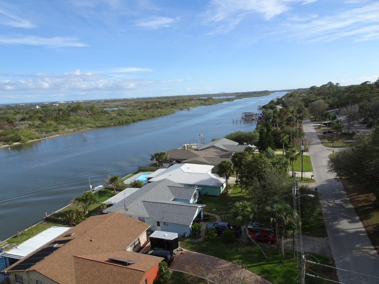
And this is looking south toward the inlet.


This sailboat is not doing so well.  Apparently, it got stuck on a sandbar, but at least the tide is coming in now.

Roof of my motorhome looks good.  The arrow points to where my TV antenna used to be before I bent it driving under some low branches in a grocery store parking lot.  Since I have a satellite dish, the round thing in the front, I never use it anyways.

 
 Another dizzying view.

 
 If I were a little bit taller, I could have stuck my camera lens into this hole and got a better picture of the lighthouse lens.  This is still a working lighthouse, so the lens was turning around. 

Whew! Walls at the bottom of this lighthouse at 8' thick and only 2' thick at the top. As you can see, it is entirely made of brick.

This is the lens museum and one of the most interesting parts of the visit here.


This is a view of the top part of the original Ponce Inlet Lighthouse First- Order Fresnel Lens. It is too tall to fit into one photo.

You can see the turning mechanism in this picture of the bottom half. Note that someone could climb the stairs to get inside the lens to maintain and clean it.

Behind and to the left of the Ponce lens is the Cape Canaveral lighthouse lens that was removed in 1995, restored, and placed here for safekeeping because the frequent rocket launches were causing vibrations that threatened to damage this piece of history. 

Some smaller lamps and lens.


 This is a strange lens!

 
My legs and back hurt, but it was well worth the trip and the climb! 


Monday, January 16, 2017

1/15 Bike Ride Loop

In retrospect, taking a long bike ride on a Sunday in a high-tourist area was probably not the best idea, even if a lot of the road was not highway.  Actually, the high way had sidewalks.  It was the back residential roads that had a lot of motorcycle and other traffic.  Lots of people just enjoying the beautiful weather!! 

The map here shows my start at the Gamble Rogers Campground where I am staying and the route I took.  Note that the four hour estimate is the walking time estimate.  Frankly, it would take me about three days to walk this route! 


I headed south along the sidewalk on Highway A1A.  It would have been an impossible trip along this very busy road without the nice, wide sidewalk.

This is looking backward after a couple of miles.  The land on the left is mostly nature reserve. 

I crossed the border into Ormond Beach, and this is High Point Bridge Park.  There is fishing here and a boat launch into the Inland Waterway.


 High Bridge Road connects to John Anderson Highway, which is really this pleasant scenic road with lots of interesting homes along it.  Many of these homes back up to waterways and have access to the Inland Waterway and the ocean.

This house looks extremely southern in architecture because of the large porch.
 
A really young brown pelican.  You can tell he or she is young because there is no white on the head area. 


A "cracker" house.

 
 And an almost identical cracker house right next door that someone has fixed up.

There were several interesting pairs of roads going to houses a long way away.  Almost all had locking gates, and I assume the houses were on the waterway, which was why they were so far from the road.

Here is another set of driveways.

These photos are taken from the bridge over the Inland Waterway back on the main highway going into Flagler Beach.  This looks south.


The Inland Waterway looking north.


The main waterway is maintained, but lots of little channels go off through young mangroves and other water shrubs. Good places for young fish and birds to hatch and grow up!

I stopped taking photos of the ride from Flagler Beach to my campground because these were shown in the earlier photos I took a couple of days ago.  In any case, it ended up being a 14 mile bike ride--tiring and hard on my arms and shoulders, even with my electric bike. 

Sunday, January 15, 2017

1/13 Flagler Beach and a Little Hurricane Damage

It is extremely easy to really get lazy around here, with the constant sounds of the surf and my view of the ocean and beach!

I went for two long bike rides this day.  This first ride, I stopped at the Farmer's Market and bought too much stuff, so I ended up coming back to the campground and putting stuff away, then going back for a more leisurely ride.  This small town is unusual because it is directly on the beach, with Highway A1A running along the beach for several miles in either direction. 

Being so close to the ocean makes it very susceptible to hurricanes, so it had some damage from the recent Hurricane Matthew.  You can see from the photo below how the pavement is new here and a temporary curb barricade has been set up so people do not park on the shoulder, which is newly added sand.
 

I noticed a lot of construction crews putting new roofs on houses.  None looked completely destroyed, but many had missing shingles or missing siding in spots.


It is hard to see, but this one had some of the aluminum missing from under the front soffit.  The sidewalk here looks new, as well.


The pier is closed, so I assume some damage there as well.

This was a very nice day for sitting on the beach--slight breeze and 72 degrees!

It was very busy in the main part of town, partly because of the Farmer's Market and mostly because of it being high tourist season. 

This kite had several strings holding it down.

 
Just a really nice day for sitting outside.