Friday, August 31, 2018

8/31 Sunny Tillicum Beach, OR

Truthfully, Tillicum Beach, and any beach along the Pacific Coast, is much more likely to be foggy or cloudy than sunny.  Sometimes the sun comes out in the early afternoon, but often it stays foggy and even drizzly all day.  In fact, most of the past week has been foggy and damp, which has not bothered me because I have had a lot of work to do for my online class.  

Anyway, around noon a couple of days ago and today, the sun came out and the fog and clouds disappeared, so I took advantage of the nice weather and went out both times for a beachwalk and to take some photos.  I am leaving for Bullard's Beach in the morning, so wanted to take some last photos.  

These first photos were taken a few days ago when it was low tide.  I love to go out during low tide because the ocean is so interesting when you can see the bottom sands. 


The hard sands makes it easy to walk. 

I took this photo of a man walking on a sandbar while I was facing the sun because I wanted to catch the light on the water. .

I have beach shoes that I can get wet, so I don't mind a little bit of shallow wading. 


The water was very clear and the sand hard, even when you had to walk in the water. 


Love the patterns in the sand. 


The campground is to the left in this photo.  You can see the fog/haze against the trees.  One problem with that fog is that is carries a lot of salt in it, so windows get covered with salt. 


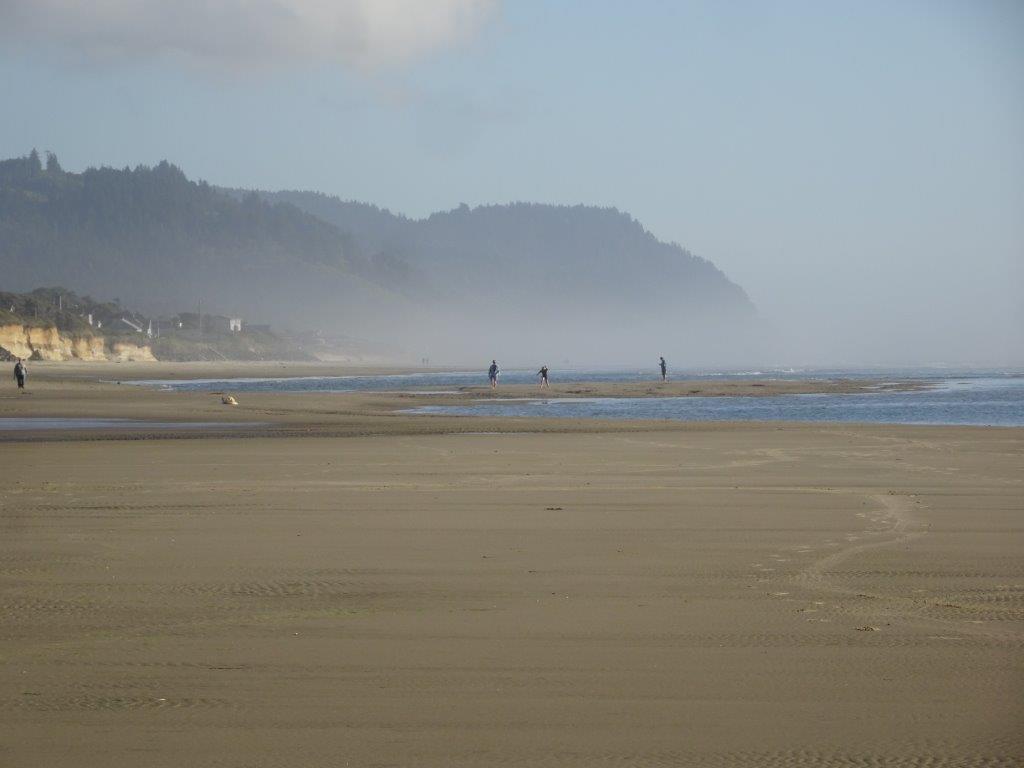
There is a creek that empties into the ocean not too far from the campground, so I walked down to it.  Almost nothing for Forest Service land in the distance, so the water is very clear. 


I took the next few photos today.  It was almost high tide, so there is a lot less beach, but considering that we have not had sun for a few days, there were a lot of people out getting some sun.  Temps have been in the low 60s all week, so you still need a light jacket.  The sky was really, really blue today, which was nice. 


I've been here for two weeks now, but it will be nice to get to another and different beach. 


Friday, August 24, 2018

8/23 Cape Perpetua, OR

Cape Perpetua is a national forest area about 9 miles south of Tillicum Beach, just past the small town of Yachats.  It is drop-dead gorgeous!  The first few photos were taken from the visitor center, which is about 100 feet above the shore.  It has a parking lot with spaces for RVs and a really nice, large deck overlooking the Pacific. 

There are lots of tide pools all over this area, but this set and the ones in nearby Yachats have convenient steps down to them.  


After the visitor center, I drove higher up the mountain to the day use area at the very top!  View is a real "Wow!" from here. 

Looking down at the visitor center using my telephoto lens. 

Looking back into the interior at the mountains.


Whoooo!  Makes me a bit dizzy to look down!  

Today was a fairly clear day, but it is hard to see the mountains along the coast in the distance with the fog banks hanging around.

Way back in the 30s, the CCC built this shelter and the road coming up this mountain.  


Finally, the fog lifted a bit, and now you can see mountains down the coast. 

8/21 Tillicum Beach Campground

Tillicum Beach Campground is part of the U.S. Forest Service, which means it is a federal facility.  Few U.S. Forest Service campgrounds have electric hookups or even water available, but this one has both water and electric for many of its sites, plus it has plumbed restroom facilities.  Unfortunately, it does not have a dump station or showers.  I really only care about a dump station, but there is a city dump station in nearby Waldport.  


This is the camp host sites and check-in.


Anyway, the best part of this campground is its location--right on the Pacific Ocean!  And not even separated by dunes and a long walk as are all the Oregon State Parks.  I not only reserved the only spot where you can get satellite TV, but it is also on the other side of the road from the beach, so if there is no one camped there, I can see the ocean. 

There are sites right along the ocean, but they have no electric or water, and I DO like electric. In addition, most of them are small and are used by tent campers.   


A large part of this campground is tucked in the trees.  Sites are relatively small, however. 


You would be able to see the ocean just to the right in this photo if it weren't so foggy! It is also pretty chilly here, with days in the low 60s and nights in the 50s.


 The entrance to the beach is just across from me, so easy to get to.

Lots of haze and fog, and this was one of the better days we had!! 

 Nice beach, though.


I'm not sure when this erosion occurred, but the cliff on which the campground rests has rock in some areas to protect it, but not in others.


I've been doing a lot of working, but it is nice to be able to take a quick break and walk around the campground or go out onto the beach for a while.

Sunday, August 19, 2018

8/18 Bonneville Dam Fish Hatchery & Really Big Sturgeons

Got a little better Verizon service for a few hours today, so am updating my blog.  

On my way to the Oregon Coast, I stopped at the Bonneville Dam Fish Hatchery.  I had stopped at the south side of the dam a couple of years ago and at the north side a month ago, but I did not realize on either of those visits that there was a huge fish hatchery near the dam as well.  And, the thing that made me stop was finding out that there were huge sturgeons in the hatchery that they used for breeding little sturgeons.  

Sturgeons are really, really big fish--like 8' long for the river versions.  There are other versions that also live in the Great Lakes, but almost everywhere in the U.S. these animals have been fished almost out of existence. The life cycle of these primitive fish is so long, however, that breeding them takes a very long time.  

At the entrance to the dam, you can turn left to the hatchery or right to the dam itself for a tour of the power plant and to see the fish ladders. 

The hatchery opened in 1909, so some of the buildings show the architecture of that time.  Here is one of the big fish ponds.  The arches support netting to prevent birds like eagles from helping themselves to an unauthorized snack. 

A map of the hatchery.  I am on my way to the sturgeon viewing center, which is at the upper left of this map. 

Thee buildings might have been a residence or office way back when.  Notice how well the grounds are kept up.  It was a beautiful day today, sunny and not too hot or cold. 

Check out the wind vane. 

Fish or not, this is a very pleasant place for a stroll. 

This little building is built into the side of the sturgeon pond and enables you to see them from underwater windows. 

I like the sturgeon wind vane on this viewing building.

These are about 3-4' long, so they are smaller. 


 This one was a little bigger.

This is  one of the views from the top. 

These two are really big! 


The water in the ponds is kept clean because it comes from a mountain stream and is then filtered.  It ends up being amazingly clear.  One thing I forgot to find out is what they feed these guys. 


 This is one of the other ponds, where mostly trout are raised.  I am not sure why it is not covered with netting like the other ones are.   Maybe the fish are too big to steal? 


Really small trout in this tank.


Hidden behind all these bushes is an RV belonging to some of the volunteers who work here in exchange for a camping spot and maybe a small salary.  

 
Bonneville Dam and the hatchery are located about 30 miles east of Portland off of I-84, which makes it an easy place to visit if you are ever in that area. Here are some links:
  • Fish Hatchery Guide -  https://myodfw.com/bonneville-hatchery-visitors-guide
  • Army Corps of Engineering site - http://www.nwp.usace.army.mil/bonneville/