Thursday, October 31, 2013

10/30 Leaving Yosemite

It was a very cold night, and as usual, furnaces were pumping out warm air all night.  I woke up to find that the temperature outside was 21 degrees and that my lights were dim because my coach batteries were almost dead.  To make it worse, my generator would not start.  That did it.  I decided that I would come back to this place sometime when it was warmer and more sunny. 

One thing I wanted to take pictures of when I drove in was the rockslide on U.S 140 that I was told occurred in 2007 and has still not been repaired.  The main "all-weather highway into Yosemite follows the Merced River for 15 miles.  The whole side of the mountain slid down and blocked the highway.  They have put up two one-way bridges and transfer traffic, one direction at a time, to the old roadway on the opposite side of the river. 

Here is one of the bridges transferring traffic to the other side of the river.


You can see a bit of the buried roadway in this picture. The landslide is to the right.

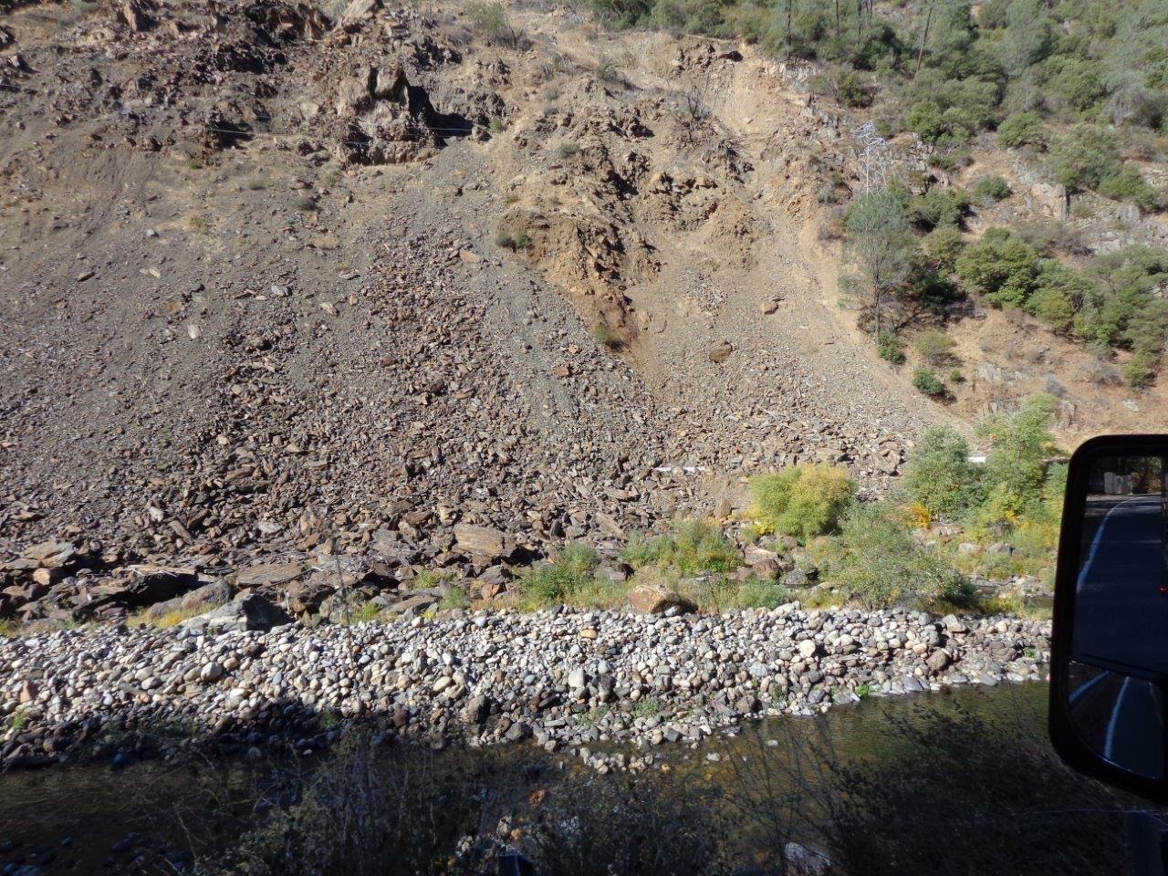
Here is a broader photo showing how much of the mountain slid down.  It is not a matter of just bulldozing the rock out the way because if you tried it, more would come sliding down.  Hope no one was under this.

You can see the roadway emerging on the right of this photo. Apparently, they are going to build a tunnel under all of this, but I am not sure how.

I posted a few days ago that I had had a rough trip into Yosemite.  The problem was NOT the mountain roads, but the county roads I had to drive on for 20 miles. This route was about 40 miles shorter than driving all the way out of Hensley Lake and then back, so I took it, per my GPS.

Can you believe the patches?  In fact, it is pretty hard to find any original road!  Everything in my motorhome rattles on regular roads, so you can imagine how bone-jarring this stretch was.
 

Ah, this stretch was MUCH better.  Somebody has spent some money on this part.  (Some politician came through on a promise?)  One funny thing was that in 20 miles of driving through these hills and passing a lot of big ranches, only two vehicles passed me.  There were NO oncoming vehicles at all!  Can't imagine why.

As I got closer to the lake, I stopped right in the middle of the road to take this photo of the snow-capped Sierras in the distance.  Pretty, but I prefer a nice sunny, warmer place.
  
My coach batteries charged during the drive, and my generator started right up once I got set up in my campsite.  I knew I would have power here, so I don't really need the generator anyway, but it was good to know everything was working again.  I assume it was just too cold this morning in Yosemite. 

10/29 More Yosemite

Most of the snow from yesterday melted over night, but it is still really cold outside so some is still left.  My furnaces both ran all night.  These motorhomes are really meant for warmer weather so are very poorly insulated and it takes a lot of propane to keep warm in cold weather.  I am using almost a quarter tank about every 36 hours, which means I cannot spend much time in this much cold.  Luckily, I have a couple of down comforters to keep me warm at night, so I tend to back off the heat at night to save propane.

Here is the campground as it looked this morning.  Normally it is almost impossible to get a camping spot here--but since almost all the tenters have gone, there are lots of empty spots!


It looks like all the snow is gone, doesn't it?

However, I took a close-up of the above scene, and you can see that the trees way up on the ridge are still covered with snow.  Both Tioga Pass and Glacier Point road were closed today because of snow and ice.

This guy was very suspicious of me, but eventually I watched him bury his acorn for the winter.

Behind the visitor center is a reconstruction of a Native American village.  The ancient peoples collected acorns and game from the area during the summer.  Here is a ceremonial lodge.

And a temporary bark summer shelter.

A sweat lodge is built into the earth.

The Merced River actually had some water in it today.  Yesterday it was mostly dry.  Actually, all of the waterfalls have been dry, with the exception of Yellowstone Falls, which has some water flowing.  I did not go there because it was too cold to walk around!

Tuesday, October 29, 2013

10/28 Yosemite National Park

Arrived yesterday after a stressful drive, mostly because the county roads I was driving on were curvy and full of chuckholes.  This stretch was one of the better.  Another section was so bad I had to drive 15 MPH and still everything was rattling, including my teeth!  When roads are uneven, my whole vehicles sways and is hard to control.  You can hear all the stuff in your cupboards and refrigerator rearranging themselves so that when you open something, everything falls out. 

Thankfully there was almost no traffic.


I had been worried about what route to take into Yosemite, but U.S. 140 is considered the all-weather route and was really quite good.  I do not mind curves, but at least the pavement was smooth and there were lots of pullouts so I could let cars behind me pass.

Almost there, and here is the tunnel I had been told about.  Made it through with a whole foot to spare on top and sides!

Spectacular view of El Capitan.  There must have been climbers, but I could not see any.
 
Went to bed surrounded by a lot of campers in tents and pop-up campers. Surprise, surprise!!
 
This is what I woke up to.  Tenters and people sleeping in small popups and the backs of vans soon packed up and left, leaving only a handful of motorhomes and trailers.  We, of course, were the ones with furnaces and running water, and real bathrooms and showers!

 
I managed to take some video, but after posting to YouTube, quality is somehow not so good:  http://www.youtube.com/watch?v=DDBpHE6SgRY&feature=youtu.be 
 
Someone posted on another forum a photo taken from the live webcam on top of Glacier Point.  I am just below there.

I never planned to be in snow country, but I guess I need to buy a hat and some gloves, and maybe a pair of stretchy boots I can put on over my shoes in case of emergency. 

Friday, October 25, 2013

10/23 More Hensley Lake

Today I got my bike out and rode around the campground.  It is very empty because of the time of year and also because the lake level is so low.  Here is the huge "boat ramp to nowhere."  If you look carefully, you can see the dam in the distance and the water intake tower.  The water level would have been low anyway, but they drained it further to enable them to work on the pumps in that tower.  Once the rains come in the winter and spring, the lake will fill up again.

I rode over six miles on the highway to the opposite side of the lake where the maps showed something called "Vista Point."  The road was asphalt and there were almost no cars.  It was so quiet I could hear them coming a long time and they just pulled around me because there was no real shoulder to move to.  Nice ride. 

Here are the photos of the other side, with arrows showing my campsite in the distance. (I should have made the arrows bigger, but they are there if you look carefully.)


Kind of sad to see such an empty lake. Most of the rocks in the middle would normally be covered with water. 

One of the things I have seen in several waterfront campgrounds in California, but also in Idaho and in Washington, are the life jacket loaner stations.  Note that they have both adult and child-size versions.  People are kayaking and canoeing here even if there is not much water available.  The ranger told me that even once had a program where they traded new lifejackets to people with ones that had holes in them or were getting too old to be safe.  I suppose it saves them a lot of rescues.


Tuesday, October 22, 2013

10/22 Eastman & Hensley Lakes

I've been hanging around Napa for the past week getting some doctor's appointments over with, but now I am back on the road for a couple of weeks before I have to go back for some procedures.  First stop was a couple of COE (Corps of Engineering) campgrounds I wanted to check out.  I prefer to stay at state and national parks because you usually have more space and privacy, plus some places to ride a bike or walk, and they tend to be less expensive than cramped private campgrounds. 

A problem with California State Parks, however, is that they tend to be very rustic and almost never have any electrical hookups, plus they are also expensive.  You pay more ($30-35) for a rustic campsite in California than one with electric and water in most other states' state parks.  Cutbacks also mean a lot of them are not in very good shape.  My meager experience has shown me that there are some terrific COE campgrounds and nearly all have a lot sites with electric and water and at least some full hookup sites for about $15 for us seniors with our federal America the Beautiful Senior passes.  Most are on reservoirs or near dams along rivers.  Most also have paved roads and paved campsites which keeps the dust down, and these vehicles get dusty enough inside!

There were three campgrounds I wanted to check out, so after cortisone shots in both hands (one trigger finger and one carpal tunnel syndrome), I headed on my way.  I got about 70 miles away, and heard a very loud bang and felt some vibration. At first I thought something inside the motorhome had fallen.   I was on a two-lane, but was able to pull over past a side road to the shoulder of an extra acceleration lane.  The tires looked fine, but I realized when I pushed on the passenger's side inside rear dually that it had no air in it--blow out! (Lucky it was not a front tire.)  So here I am!  Luckily I have CoachNet road service, but it took 3.5 hours to get someone there to put the spare on. 

Last night I stayed at Eastman Lake, northeast of Fresno, CA.  I did not get there until well after dark, but got help finding a site from the camp hosts.  With everything, it had been a very long day!  Had a great site with full hookups (water, sewer, and electric) but no cell service or internet access through Verizon data.  Here are some photos of that area.  Very nice place, other than the lack of connectivity.  Note that water level is extremely low--partly because of the drought, but also partly because they have lowered the water levels to work on the water pumps.


This morning, I packed up and moved to Hensley Lake, about 20 miles south.  I like this one better because it is more open, and you have a better view.  Decent cell voice service and OK data service so I can use my hotspot to get internet.  This campground is very hilly so sometimes picnic tables are several feet above or below your campsite.  They have put stairs and sometimes sidewalks to access them, however.

Nice paved spots with awnings over most picnic tables!

This lake is also very low for the same reasons as Eastman Lake was low.  Boat ramps were closed, but you could use kayaks in the lake.

 
Found this guy near my campsite.  Very well camouflaged!
 

Thursday, October 17, 2013

10/15 Bodega Dunes & Beach

I stayed here just a couple of nights, and the campground was not my favorite because of the lack of power and the trees that prevented much of a view, so I did not take any photos of that.

However, I did decide to walk down to the beach, even though I had been told it was about a mile away.  Finding the trail was difficult, but I got some directions from one of the camp hosts.  The first bit was gravel, but then it turned to soft sand that was a struggle to walk on.


Found this flower on the way.  I need to find out again what this plant is called but it is a succulent and very common in the dunes areas along the coast.  This is off-season for flowering plants, so I was lucky to see any flowers at all.

Finally, the road appears!  Much easier to walk on.  I could not have driven on this because the day-use areas were all closed at this park.  Does not make sense with so many people traveling. 

Almost there, or at least I could see the ocean.  Still quite a walk from this point.

Whew.  Finally made it.

Only problem was that the end of the walkway had no stairs down to the beach.  There was a log someone had set up, but I was afraid that I would not get back up with my bad knees, so I sat on the cement for half an hour and enjoyed the breeze and watching the ocean.  Not too many people, and the restrooms and water fountains were completely closed.


Monday, October 14, 2013

10/14 Sonoma Coast & Fort Ross

Since I had to change campgrounds today due to construction, I decided to drive up the coast to Fort Ross.  It was a 25 miles, drive along the coast on a very winding U.S. 1.  At times, the road almost hung out over the ocean, with no guard rails.  This is the route that goes all the way from San Diego to the Canadian border and is very popular with bikers, motorized or otherwise, but I would NOT want to ride a bike along this road.  A light tap from a large mirror or the wind from a vehicle could easily send you over the edge in some places.  Very pretty, however, but it took all of my concentration to even drive 25-30 MPH on this road!


Fort Ross was a Russian settlement established in 1812, very early for California.  It was named after "Rossiia" or "Russia" and consisted of Russian fur traders, farmers who were trying to grow crops to support the Russian settlements in Alaska, and Inuit natives that the traders brought to trap seals and otters.

This is a replica of the first windmill in California.  It ground grain to make flour, although the Russians were not able to grow much wheat here because of the climate and poor soil.  They did grow other crops and pear, apple, cherry, quinces, and peach trees successfully.

Most of these buildings are replicas, but the Russian Orthodox chapel shown on the far right is original. 
 
Inside of the chapel.  The rangers said this church was still used by the Russians living in this area.


Nice view from the fort!  One of the reasons for the placement of this fort at this location was this port and a good source of water from a nearby spring.  Also, the land was flat enough to grow crops.


I took the following photos on the drive back to Bodega Bay.  There are a lot of these pull-offs and beaches along this part of the coast, but I stopped at only a couple because most were too small or too crowded for my big vehicle.  Pacific is a lot more pacific today than it was two days ago!