Thursday, December 26, 2013

12/26 Christmas at Lake Mead

I enjoyed the relaxing three days I have spent here at Lake Mead.  I had splurged on a full hookup spot with a view of the lake and am glad I did.  Hardly anyone here, so nice and quiet.


They have a very long, very nice bike path all the way along the lake from Boulder City!  I am always happy to see asphalt bike paths because there is much less chance of my falling than on gravel.


There are several big marinas on the lake.

This is the beach.  The sand has a lot of gravel mixed in, so I am not sure I would want to walk barefoot here.


And how often do you find one of your cousins in the next door campground when you travel around the country??  Bob and Becky invited me to Christmas dinner, which was outside and very pleasant.  Good food, too.  They are living full time in a motorhome, also, but have done so for several years so they are experts.


Friday, December 20, 2013

12/20 Petroglyph Canyon/Mouse's Tank

This is a half-mile fairly easy walk on red sand and over a very few rocks.  It is called both Petroglyph Canyon for the many rock paintings and Mouse's Tank after a renegade Paiute who used the many canyons to hide from authorities.  At the end of this canyon is a "tank," or a stone or a hole in the rock that holds water after a rainfall.  This tank was obviously used for centuries as a source of desert water because of the many petroglyphs on the walls.

This is the entrance to the canyon:


Parts of the red canyon wall become dark because of reactions with the air.  These sections make great writing tablets.  All the Native Americans had to do was peck at the surface with a rock to produce an image.  Look at the amazing variety of drawings on this section.

And this section.  Actually, the fact that most of the writing in on the darker sections make it easier to search for the petroglyphs.

This group were about 30' high on the canyon wall.  Don't know how they got up there.

Here are more drawings on various rocks. Some of the drawings are faded and others were partially destroyed when chunks of the soft rocks would fall off. 


I took this picture because I wanted to show the layering patterns in the rocks and the naturally occurring holes.

This is the tank known as Mouse's Tank.  The water here may have come from rain that fell months ago.

Another photo showing how this red rock has eroded over time.
 
Very nice walk, and well worth the hour or so it took.  The sun was getting low in these last photos so I knew it was time to go back to the campground--after fixing myself a quick sandwich, of course.  It is so nice to have your vehicle with you all the time so you can use the bathroom, wash the dust off of you, and fix a meal or get a drink from the refrigerator! 

12/19 Lost City Museum, Overton, NV

I went into the nearby town of Overton to check it out and get gas.  I also knew there was an archeological museum, so I made sure to stop here. It does  not look like much from the highway, but was much bigger and better than I had expected.

The main building was built by the Civilian Conservation Corps at about the same time Hoover Dam was built.  The location, on a bluff overlooking the town and Lake Mead valley in the distance, was the originally location of an Anasazi village.


I could not take photos inside, but these buildings next to the main exhibit hall are reconstructions built on original Anasazi  foundations.


This part of the small village was left unreconstructed.

This is a pit house, also reconstructed on original ruins.


The ancients chose the location well because from this slight hill you can see in all four directions. 

12/18 Valley of Fire State Park, NV

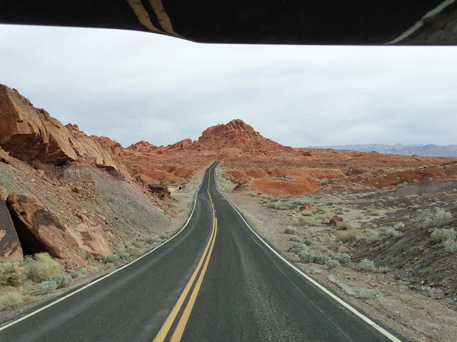
This state park, about 50 miles north of Las Vegas, was very strongly recommended to me.  That recommendation was not a disappointment!  I like to take pictures of long, empty roads, and this is the one entering the park.


What a campground and what a view!  Actually the campground is one of the most scenic places in the park.  Nice spots, many with electric and water hookups.  The only negative is that the sun sets behind the big rocks at 4:00 p.m. this time of year. 

 
The red rocks are sandstone from beneath an ancient sea.  The darker and higher mountains in the distance are also sandstone, but from a different and older sea. You can see my motorhome in the far right.


 This is a very nice picnic area near this group of rocks which are called the "Seven Sisters."  Nice place to sit and eat in the shade, especially in the hot summer.


Wednesday, December 18, 2013

12/17 Hoover Dam

It has been almost 15 years since I visited Hoover Dam.  There are some major differences I noticed since then:
  • All traffic used to drive over the dam.  Now, there is a highway bridge a few hundred feet away that bypasses the dam.  I assume this was due to the amount of traffic and also security issues since 9/11.  There is a long list of vehicles that cannot go over the dam, including large trucks and buses with luggage. 
  • They now charge $10 for parking and $10 just to go inside the visitor center.  And no senior discount!  I think that is a bit steep for a national park site.  You can avoid the parking fee, however, by driving over the dam and parking in one of the lots of the other side, as I did with my big vehicle which does not fit in the parking garage.  It just means a slightly longer walk, but I am getting used to long walks as large vehicle lots are always out in the boondocks!
  • All vehicles now go through security inspections.  I had to let the officer look in my vehicle and into all of the locked storage compartments underneath, while I stood outside and unlocked and locked them.
  • They have moved the visitor's center closer to the parking garage and away from the bridge. A bit more walking.  The gift shop and café are in another building right next to the parking garage. 
Anyway, it was neat to drive across the dam, even though I did have to watch out for pedestrians and people backing into the roadway to take photos.

I ended up parking in a lot way in the distance between the two left towers!

Even after paying my $10 visitor center fee, I could not find a single person to ask how low the water level has to get before these water intake towers ran out of water.  The level seemed awfully low.

Last time I was here I took the power plant tour, but never got to this side of the dam.  I thought this water overflow tunnel was pretty impressive.  It was used to enable the Colorado River to bypass the area during construction and can be used in flood conditions.  Apparently, it was only used once during floods in 1983.

The tunnel goes under the road, but here it is on the other side as it goes through the mountain.

Looking at Lake Mead from the center of the dam.

I thought these brass doors were impressive.


You can still see how the cement for the dam was poured in blocks.

And this is the new bridge bypassing the dam.  I can't imagine how they managed with all the traffic previously, as this is really the only bridge in a very long way, and it was completed in 2010.

Headed back across the dam.
 
Can you guess what these bridges are for?  No roads up there and pedestrians are not allowed.

 
A clue is that it is built near a ridge.  This is a bridge built specifically for Bighorn Sheep.  These animals will not go through a tunnel or even a bridge where the approaches are lower because they prefer the safety of sticking to high ridges.