Saturday, August 31, 2024

8/31 Boat Trip from Waterton, Canada, to the Ranger Station at the U.S. End of the Lake

This is a really nice two-and-a-half-hour boat tour that goes from the top of Waterton Lake in Canada to the far south end, which is in the United States.  There is a ranger station and Peace Pavilion at this south end which is only accessible by boat and very energetic hikers, so it is well worth the trip to see the fantastic mountains along the lake.  

There is a pleasant little park next to the boat dock with a commemorative sign and several large boards describing the park and its wildlife.  


Long line to get on the boat, but I managed to set a seat on the top so I could more easily take photos. This boat is owned by a U.S. company and was constructed on the lake, mainly because there is no river deep enough to get it here in one piece! 


There are a lot of lines along the mountains that are the result of rock slides and melting snow, but the one on the far left is very straight and it indicated the border of the U.S. and Canada.

There is a similarly cleared line on the other side of the lake, indicating the border.  Note the identifying post near the shore.

More mountain photos.


And finally we arrive at the boat dock at the U.S. end.   A short walk to the right is the rangers' area.  There are several of them who live there year round.  They access this place from Waterton, as there are no roads anywhere near here.   The building shown has rest rooms and posters about the peace symbolism of the two glacier national parks.


Mount Cleveland, which is the tallest mountain in either park.

Pretty view towards Waterton! 


Notice the upside down V-shaped fold in the rock here.  This must have taken eons of time and a lot of pressure.

Here, a small stream empties into the lake and makes you want to stop and wade it in.  However, this lake and the streams that flow into the lake are extremely cold because they are mostly recently melted snow, so I don't think you would want to do it very long.

Just some beautiful views of mountains heading back to Waterton.  In this one, you can tell we are getting close because of the view of the Prince of Wales hotel in the center, slightly to the right.


A view of the campground where I am staying.  Can't see my rig, however.

Only the mountains on the west side of the lake burned in 2017.  The ones on the east side, shown in the photo below are still green and have a lot of living trees on them.

Personally, I think these two people on waterboards are a bit nuts, considering the temperature of the lake water.  Brrrr.


Great visit to Canadian Waterton Lakes National Park.  I really enjoyed the views, the full hookup campground, and the little town.  I even got some of my Christmas shopping done!!

Tomorrow, I take a short drive to see another lake that is within this national park.  Then, I head north to a buffalo jump called "Face Smashed in."  (If you are a buffalo or bison, and are forced to jump off a steep cliff, you definitely have a smashed face!!  More on that in a couple of days.)


Thursday, August 29, 2024

8/29 Waterton Lakes National Park, Alberta, CA

If you have been to Glacier National Park in the U.S. on the border of Canada, you may know that the lake and the glaciers continue into Canada as Waterton Lakes National Park.  When I was in the U.S. Glacier National Park a few years ago, I took a full-day bus tour that took us along the Going-to-the-Sun Road and also briefly into the little town of Waterton in Canada.  It had a fantastic campground that bordered an attractive little town, so I decided to go there as soon as I could. Unfortunately, COVID interfered with my plans when the border was closed.  

So, last year I planned a several week trip from Michigan, along the TransCanada Highway to Waterton that would also include several other places in Ontario, Manitoba, Saskatchewan, Alberta, and British Columbia.  Plans included stopping on the North Shore of Lake Superior,  Lake Louise, Banff, Calgary, and Jasper.  So, here I am finally in Waterton Lakes National Park Campground!!

The last few days of driving took me from Moose Jaw, Saskatchewan, and Medicine Hat, Alberta, to Waterton, and that meant I went from the prairies to the Rocky Mountains in one day.  Frankly, it was a pretty sudden change.

On Tuesday of this past week, I came across this area of what looked like snow in the prairie. Actually, there were several companies using salt brine ponds to produce salt.  You could see a light layer of salt on the ponds that had been dragged into rows of salt hills.  Very strange looking!  You can see how flat and barren this land is, in any case, because we had left most of the wheat fields of Saskatchewan behind us.  Also, nice to not have much traffic on the highway.


Tuesday started out nice and sunny, and warm, with only a few clouds in the sky.  That was to change fast.

 
As I got closer to the Rockies in mid-afternoon, I could see some serious storm clouds in the distance.  (Please excuse the occasional bug splatters on my windshield.  I'd been trying to wash them away with windshield fluid, but it was not enough.)


And the rain begins and got heavier the closer I got to the mountains!!

My technique for taking photos while driving is to point my camera towards the front, through the windshield, and take a lot of photos, hoping a few will be good.  Today, I had to take photos between wiper passes!

One advantage of the heavy rain was that it cleaned my windshield!  As I drove past the entrance booth, it was raining heavily, and I felt sorry for the three bike riders that had 2-3 miles to go before they got to shelter.  (Happy in such instances to have a nice, warm motorhome.)

This is the famous Prince of Wales hotel, perched on a hill with views over the lake and the mountains.

Almost there, but impressed with the craggy mountains. 


After checking into the campground, I managed to race outside just long enough to hook up my electrical connection and to get my water hose out to add just enough fresh water to my tanks. 

What a difference 36 hours make!  After spending yesterday completely inside because of the cold temps and heavy winds, I woke up this morning to sunshine and much better views of the mountains surrounding the campground.  (High yesterday was 47℉ and low overnight was 37℉--not exactly what I expect in August.  I kept two small electrical heaters going all night and used my down throw as an extra blanket.)  

High today is expected to be 66℉, although lows tonight will only be 41℉.  Highs Friday and Saturday are expected to be a more reasonable 72℉ and 74℉, respectively. 

This afternoon I walked the few blocks through town to the ticket booth for the boat tours of the lake.  I am going to take the two-and-a-half-hour Saturday 1 p.m. tour that goes all the way down the lake into the U.S. and stops at a ranger station at the end.  You don't need a passport for this tour, so I assume they check you in and out.  

You can see the Prince of Wales hotel in the distance.  Love that location! 

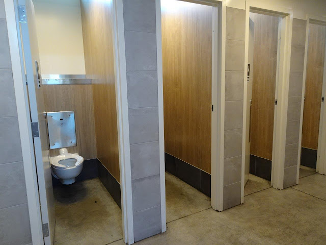
Saw this door at the restroom and assumed it was a single handicapped room.  But it was the only door I could find, so I went in and was surprised to find a man cleaning a large restroom.  I checked the door and realized that this was a combination restroom as I had seen a few times in Europe or the UK.


Basically, this is a "uni" facility for both men and women.  The stall doors go all the way to the floor and the ceiling, so there is complete privacy, but it is a little concerning the first time you experience one of these!!

After getting my ticket for Saturday and using the uni restroom, I headed to the little shops and restaurants just a block away.  Even did some Christmas shopping for a couple of people, who shall remain nameless!  (Most of my holiday shopping for my family is done in tourist towns or national park visitor center gift shops!)


Headed back to the campground and found this little park on the lake.  

After the rain all day yesterday and the day before, today was sunny but windy, as you can see by the whitecaps on the lake.

There was a major fire in this Canadian national park just a year ago, so most of the mountains are covered with dead trees. 

A view of part of the campground and my motorhome.

Can't beat waking up to these views!

I'm going to the visitor center tomorrow and see if there are any places I can drive my motorhome to nearby.  Wish I could hike or at least walk long distances, but those days are gone. 


Friday, August 23, 2024

8/23 TransCanada Highway from Thunder Bay, Ontario, to Moose Jaw, Saskatchewan

 In the last few days, I have driven 842 miles from Thunder Bay to Moose Jaw, and crossed a confusing time zone situation.  Ontario is on Eastern Daylight Time, and Manitoba is on Central Daylight Time, but Saskatchewan, where I am now, is on Central Standard Time.  This means it does not recognize daylight savings time.  This means that here in Moose Jaw, it is now two hours from the time in Thunder Bay.  

Now, to make things even more confusing, Expedia says that Saskatchewan is actually "geographically" in Mountain Standard Time, and each town in the province can decide if it wants to be on Mountain or Central Standard time.  I am here in Moose Jaw for two nights, and then will be spending the next two nights in Medicine Hat, which is over the border in Alberta, which is definitely on Mountain Daylight Time.  

Also, I am getting my satellite TV from Dish, which thinks I am in North Dakota.  I will reset things to pretend I am in Glacier National Park in Montana when I get to Alberta, so I can get locals from there.  And in the meantime, I will go by local time here in Moose Jaw.  Luckily, I will be spending most of the next few weeks in Calgary, Banff, and Jasper, which are all on Mountain Daylight Time!!!  

If you want to read the history of why Saskatchewan is so confusing time-wise, check out these articles:

Anyway, glad I am here for only two nights!  The point of this posting was actually to show you how the scenery has changed from the trees to plains on my drive from Thunder Bay.

Trees, trees, and more trees for about 300 miles after Thunder Bay. 


I drove past this sign and was determined to get a photo, but it took me driving seven miles down the road before I found a place to turn around.  We usually think of streams flowing east or west at the point of the Continental Divide, but this is another type of divide.  Streams here, empty into the Arctic Ocean, not the Pacific or Atlantic Oceans.   


I spent a night near Winnipeg, Manitoba, about 200 miles west of Thunder Bay, and right after that city, the scenery changed from trees and an occasional farm, to a lot of farms, and then much bigger fields with almost no patches of trees.  The really nice part was that after Winnipeg, the TransCanada Highway became a four-lane, divided highway. 


Interestingly, even though I have been given numerous warnings about long stretches of highway without gas stations, I have found gas about every 20-25 miles, and those stations are nearly always accompanied by a Tim Horton's.   

Did you know that each honey-dip Timbit has 50 calories??   Enough said.