The last time I came to Death Valley, I came via the southern entrance. This time, since I was coming from Tehachapi, I ended up following my GPS's instructions through Mohavi and then through the Searles Valley, across a range of mountains, and then through the Panamint Valley, before crossing the Panamint Mountains and entering Death Valley from the west. The road was paved and mostly smooth, but almost completely empty. And the drive was not only interesting, but very beautiful. Who says the desert is empty?
I filled up with propane this
morning in Tehachapi before I left and stopped in Mohavi to top up my
gas tank since I knew there would be no services before or even in Death Valley. In addition, my refrigerator is stuffed, and I have lots of groceries to last more than a week. I also did laundry yesterday and washed my rig, so I am prepared for anything!
After experiencing California traffic around San Diego and in the North Bay area and around Fresno, empty roads like this are a real treat! The first few photos are between Mohavi and the Searles Valley.
Now, THIS is boondocking! RVers call camping in someplace that is way out in the middle of nowhere without any services "boondocking." In the west, there are many Forest Service or Bureau of Land Management places where camping is allowed along what are really just paths in the desert or in the woods. There are rules for such camping, however. If you want to read a blog by someone who does this almost entirely, check out RV Sue and her canine crew at http://rvsueandcrew.net/ or do a search for "RV boondocking."
This area allowed off-road vehicles, so I am guessing that's why this rig was parked here. They may have off-road bikes or four-wheelers. Or maybe they just like peace and quiet.
Lots and lots of road and scenery and almost no cars. In fact, I stopped right in the road several times to take photos, checking behind me of course to make sure no one was coming up behind me.
An interesting rock formation.
Love being able to see so far in the distance!
A very long way from anything is Searles Valley. It is west of Panamint Valley, which is west of Death Valley! So I have two valleys to drive through today in the Mohave Desert before I get to Death Valley.
The
Searles Valley has some big mining operations. A pullover site said
they do not strip mine, but drill wells and pump water down to dissolve
minerals and then pump it back up again, which is supposed to be better
for the environment. Not sure of that, but there were a lot of big
evaporation ponds. Here is some information about Searles Valley Minerals: http://www.svminerals.com/default.aspx
A pile of salt or something.
Unfortunately, the town of Trona has not been doing well in the past few years. According to this CNN article, it once had 7,000 inhabitants, but is now down to 1,000 because technology has changed in the mining industry. Sad. CNN article link: http://www.cnn.com/travel/article/cnnphotos-trona-mining-town-california/index.html
Headed out of town and north through the Searles Valley, up through a 4,000 ft. pass, and then into the Panamint Valley.
Once in the Panamint Valley, the Panamint Mountains were to my right, following the valley. The form the western border of Death Valley, so have to go over them through another pass to get there. At this point, I am still 60 miles from Furnace Creek Campground and the visitor center.
I stopped at a paved area with several historical markers. In the distance, at about 12 o'clock, way high up on this mountain is the old mining town of Panamint City. It was destroyed by a flash flood in the 1800s. See the signs below for more information.
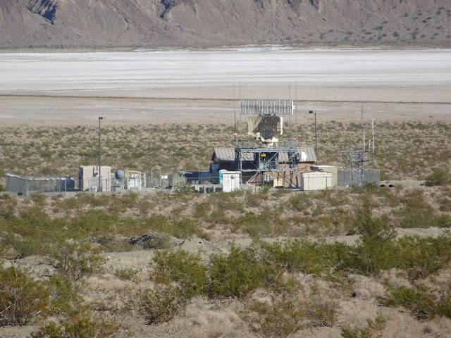
This was visible several hundred feet away from the historical markers area. It was rotating and looked like some sort of radar installation. Not sure if this is military or weather. I do know, the area was buzzed several times as I was walking around reading the signs by some very noisy military jets that I assume were flying out of Edwards Air Force Base.
About a mile down the road was a sign marking Death Valley National Park. Actually, only the right-hand side of the road was national park. The other side was private land. Two other vehicles stopped here and took photos, which was the biggest crowd I had experienced all day!! Incredibly quiet, and I could imagine Wylie Coyote having a rough time getting a meal in this area.
Turned right on a slightly more major highway, though still pretty empty. Have to go over another pass
Notice how colorful the mountains are. Each color indicates a different mineral.
Heading over the 4,500 ft pass to Death Valley.
And there it is in the distance.
HAVING TOO MUCH TROUBLE UPLOADING, SO TO BE CONTINUED IN THE MORNING.


No comments:
Post a Comment