Sunday, February 28, 2021

2/28 Homolovi Ruins SP, WInslow, AZ

This is a state park I have stayed at before.  It is just a couple of miles off the I-40 freeway that goes past Winslow, AZ.  I needed a place to stay between Laughlin, AZ, and City of Rocks State Park in New Mexico, so I stopped here for one night and visited the ruins in the morning before I left the area.  

The ruins are the remains of at least two villages occupied by the Hopi from the 1200's to the 1300's.  The ranger told me there were obviously ancient Indians living there for thousands of years because they have found large spear points that would have been used on ice age animals, but no dwellings have been found.  

This is an interesting place because wherever you walk, you can look down and see pieces of pottery and chert from which spear points and tools were knapped.  The ranger said that before the state took over the property, people had come in with bulldozers and diggers of various types.  He said they estimated that over 75 cubic yards of ancient material was removed during that period.  In any case, there were two very large villages here, so lots of broken pottery still left wherever you put your foot down, which means you should stay on the paths.  

This also explains why there are almost no existing walls--everything original was dug up!  Anyway, here is an image of the first village--Homolovi I.

About all that is left is this rise or ridge in the distance.

Visitors have piled up pottery shards, but you really should not be doing this.  In any case, you can see the various types of pots that were made.


I bent over and picked up this piece of chert from which pieces had been chipped off about 700 years ago!  And I did put it back exactly where I had found it.

To the left of the photo below, you can see the floodplain of the Little Colorado River.  There would have been farms here instead of the brush you see now.


More pottery shards.

And more.

Another piece of knapped chert. 


They were allowing only one person or one family in the visitor center at one time.  It is cold this time of year because the state park is at 5,000 feet, so the campground was only about 30% filled also.  And people were very good about wearing masks.  Very safe time to travel via RV. 

You can match up the pottery with the shards piled up on the rocks at the ruins sites.


After the visitor center, I drove to Homolovi II, the second village ruins.

This map shows how really large this village was.  With 1,300 rooms, there had to be room for 1,000 people and for storage of grain grown near the river.


Lady walking around pointed out some wild horses in the distance.  I had to use my telephone, so not crystal clear.


OK, I am all caught up with postings.  Will try to keep up a little better.  Next posting will no doubt be City of Rocks State Park in New Mexico. 


2/22 Even More Willow Beach

 Long story, but the State of New Mexico cancelled my February camping reservations because of the coronavirus.  I also had not done laundry for five weeks because I did not want to use a commercial laundromat.  So, I drove back to one of my favorite places along the Colorado River.  I even ended up in the same site as I had been in just three weeks before


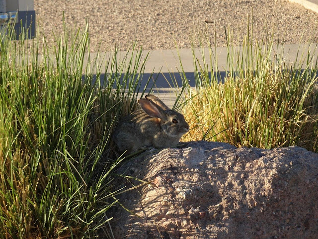
And yes, the bunnies are still there.  There is new growth on the clumps of grasses that were cut back, but when you are a very small rabbit, you need to be creative.   Note the big ears on these guys.  Helps to cool them in the hot desert!

 This bunny at a nearby campsite took advantage of a rock to reach the succulent new grass.


Almost all federal, state, and county campgrounds rely on paid or volunteer camp hosts who live in RVs in the campground.  They do light maintenance and help campers are when needed.  In very hot places, the campground will provide a structure to help keep the sun off the rig and make it cooler.  This campground installed a super-sized structure with mesh side curtains.  (There is a 40' Class C bus hiding under this one.)  The camp host built a storage unit across the entire back end so as to provide even more sun protection.  The front is open and mesh still allows a lot of fresh air.  This is actually one of the nicest sun protection structures I have seen in campgrounds.

 
My foot is finally healed from my late December bike ride in Napa, so I got my bike out and rode down the hill to the visitor center/store.  The campground is a long way up a slope to protect it from floods that destroyed the original campground in 1972 and killed 19 people. 

 
The road down to the river goes over this "wash."  A wash is a sort of dry river where water flows safely during heavy rains.  It does not rain very often in this area, but when it does, it rains a lot.  And this wash drains a couple of square miles of mountains slopes.  The roadway is on the left, behind the piles of gravel.  

One interesting fact is that this is the ONLY road getting to and from the campground and the rangers' residents.  So, when this floods, we are all going to have to just sit and wait for it to empty.  They do keep heavy equipment around because it is also possible the road will be washed away. 

Notice the piles of gravel in the middle of this photo?  This was removed from the road the last time it flooded. 


In spite of the bareness of this area, it really is a beautiful place. That is the Black Canyon of the Colorado River in the distance.

You can rent a kayak or even a boat, or bring your own.  The river is clear and cold here, so very nice in hot weather.

And the marina, looking upstream.  Hoover Dam is about 13 miles this direction.  Almost all of these boats are rentals.

This is looking downriver. 

The fishery in the distance.  You can just walk in and and look around during daylight hours.


You can sign up for a float trip from near the base of the Dam all the way back here to Willow Beach. I did that last fall.  It is very large raft, and you will not even get your feet wet.  They provide box lunches, water, and a portapotty, which they put behind a bush at a stop about halfway down.  Only problem is that desert bushes are not exactly dense enough to provide much privacy! 


This was taken from the picnic area about halfway up the road to the campground.

 
This is the road out of the marina back up to the highway.  This is one of two short sections that keep getting washed out by rain, but you can see the piles of gravel that were removed from the roadway.  I was told that they have the money to build a new road, but they have not yet decided where to put it so it does not get washed out every few months.  

Back up on Highway 93, there are two scenic view areas.  You can see the river in this photo, but the campground and marina are hidden behind the hills just this side of the river.  

A couple of closeups of the river and marina area. 


2/14 Tuzigoot National Monument, Cottonwood, AZ

I'm am trying to catch up with postings for February, so here is one I should have posted two weeks ago!!   I've posted on this before, but in case you missed the old posting....

This place is on a ridge about a half-mile north of the town of Cottonwood, AZ, so it is easy to reach if you are staying near there.  It is also not that far away from Sedona, AZ.  I was staying at Dead Horse Ranch SP and could see this from the campground, although it would have been a very long hike to get there.  Better to drive.  Luckily, the small visitor center was open and the ruins themselves are outdoors, so it is an easy place to visit in a pandemic.  It is not a large place, so you can walk around it in about 30-45 minutes.

Tuzigoot was built on a ridge by the Sinagua people near Mesa Verde river.  They grew crops in the flood plain and hunted deer and other animals in the area.  It originally had 110 rooms and was occupied between 1125 and 1400 CE. 


The visitor center.

And some of the displays inside. 

Quite a view from this place.  The town halfway up the mountain is Jerome, AZ.  It is an old copper mining town and there is a mining museum part way up that is now a state park.  It is a steep drive up the mountain if you are driving or pulling an RV, so better to go up in a car.

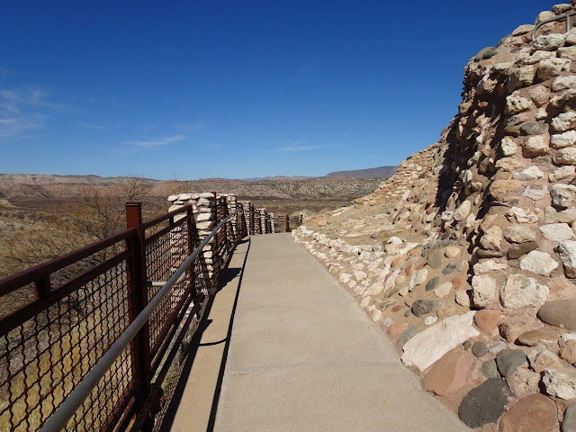
Back to Tuzigoot and views of some of the rooms.


It was a beautiful 70 degree day with a light breeze, so it was a perfect day for a visit.