Saturday, March 29, 2025

3/25 Oliver Lee Memorial State Park, Alamogordo, NM

Back to finishing the postings about this campground, about 12 miles south of the town of Alamogordo, NM.  I have been here a couple of times before and have enjoyed the desert and the views from the campground, but this time, it has been especially cold and windy, plus because it has been so dry here, almost none of the desert plants are in bloom.  This has been a strange winter for all of New Mexico because of this drought and colder-than-usual winter. 

This state park is located in the Chihuahuan desert on a slope up against the Sacramento Mountains, which run north and south for 85 miles and are 40 miles from east to west.  To the east, about 15 miles away, you can just barely see the white gypsum sands of White Sands National Park.  The state park and Alamogordo are about 4,500' in elevation, where the Sacramento Mountains are 8,000 to 10,000' in elevation, so you can quickly drive from dry and dusty desert to heavily wooded mountain scenery! 

I have been to White Sands National Park at least three times in the past and have also driven into the mountains in the past, so with the dust storms and cold weather here, I skipped them this trip. 

It is a four mile drive from the highway to the campground, which you can see as some tiny white dots on the beginnings of the slope of the mountains in this photo.


I arrived here just in time to get hooked up and filled with water just before this dust storm arrived and kept me indoors for the first couple of days of the two weeks I spent here.  


A couple of days later, when the dust storm subsided, I took some photos of the yucca plants which were in bloom, but a little the worse for wear based on the wind they had survived.


The campsites are mostly large, but strangely they are square and not very level, so it makes it very hard to get into and out of.  Plus, only about 40% of them have electric and water hookups.  I had made my reservations a long time ago, so I had both.  Just wish my site had been more level! 
 
One of the very few cactus in bloom in this campground.  

Beautiful views up towards the mountains.  The canyon that you see in this photo has a year-round small stream that provided water for the old ranch that used to be here.

 
This is a view looking south along the Sacramento Mountains. 


I took a walk to the visitor center one day to take some photos of the little cactus garden and some ruins of a tiny home that was once lived in by a hermit.

If you look closely at this photo, you will see that the natural ridge at the top has been supplemented by a rck fence that kept cattle in specific areas of the ranch. 


To the right of the visitor center is another mountain with the remnants of an old mine of some sort.  Wish I were younger and in better shape so I could have walked up here, but it was a steep and strenuous trail.

 
Sign announcing the little cactus garden near the visitor center.  Unfortunately, nothing was in bloom yet here. 


Just over to the side of the garden on the other side of the entrance road is a reconstruction of the home built by a man who worked on the ranch but was mostly a hermit of sorts.


A view down Dog Canyon where there is a year-round stream and a few green trees. 


Another rate cactus in bloom.  

A view looking southwest along the valley into another, more distant mountain range.


I have no idea what this plant is, but it was in bloom just before I left.


Not sure when or if I will be back here, but I did enjoy the last week when the weather was better, with no dust storms!


Wednesday, March 26, 2025

3/22 Oliver Lee State Park - Ranch House Tour

I'll be posting photos of Oliver Lee SP tomorrow night, but tonight I want to catch up on a tour I took here on this past Saturday.  The ranch house is on state park property, but it is behind a gate that only rangers and camp hosts are allowed to go.  The tour is offered only on Saturdays, and I missed the first one of the two weeks I have been here, so i made sure to sign up for this one.  

We drove single file in our own vehicles through the gate which was unlocked for us and down a narrow road.  Big parking lot for my motorhome, at least.  

The camp host did an excellent job of being a tour guide and explaining the huge area that was originally a ranch in the late 1800s, and eventually became a state park in the 1950s.  The strange thing about the tour is that we were met by two, heavily armed state park rangers.  And by heavily armed, I mean with bulletproof jackets, guns, ammo belts, and all kinds of seriously looking stuff attached to their uniforms.  The camp host said they were there for our protection.  Basically, they looked ready for a major gunfight!  I know we are about 60 miles from the Mexican border, but it seemed a bit overkill, though I admit I don't know what kinds of problems they have been having in this area. 


This is a photo of the campground in the distance.   Notice that there is a canyon going off through the mountains behind the campground.  This long range of mountains has quite a few of these canyons that each had small streams in them, allowing ranching in good years. 

 
The ranch eventually included one million acres, so it included a lot of land, and the photo below shows a canyon directly behind the ranch house.  The white things in the far distance look like dams that were built to hold water for the ranch and cattle.  More history of the ranch and the state park can be found here.   

Basically, the history of this ranch and area includes Indian wars, cattle rustling, gun fights and killings, and a lot of rough characters. 

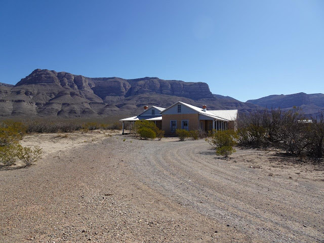
Now, this is the ranch house, but it is not the real ranch house that the Oliver Lee family lived in.  That house fell apart and was finished off when Disney reconstructed it to use in a movie and then asked the townspeople to shoot it up, so it looked like it been part of a real gunfight. 

It was reconstructed after archeological digs identified the old walls and where the old outbuildings such as the barn and butchering building was located.  It is still in the process of being reconstructed, but the project is on hold, we were told, because they need to remove the floors and fill the open spaces below the floors because that area has become a home for dozens and maybe hundreds of rattle snakes.  The plan is to fill the area with gravel and then build a snake impervious barrier around the edges!  Apparently, this is an interesting place in the evenings or early mornings when the snakes come out! 

 
This rooms was used as a school for the many Lee children.  The floor has been removed to start adding gravel.  

As you can see, there are informational displays which need to be added to the walls.  I took pictures of a few, even though they were covered with plastic.


This room is also a reconstruction, but it copies the original adobe walls.


Some photos of the outside and explanatory signs.

If you can imagine it, when Oliver Lee moved here in 1893, they had had several wet years in a row, so this normally very dry desert was said to be waist deep in grass.  However, after a few years, it was so heavily grazed that the grass disappeared and never came back.

And back we go!  Minus the impressing armed rangers, obviously. 

I'm heading to a different state park in NM tomorrow, and also have to stop along the way and pick up some packages I ordered, but hopefully I will post about the campground tomorrow.


Friday, March 21, 2025

3/20 The Museum of Space History, Alamogordo, NM

This museum and the town of Alamogordo, NM, is near one of my favorite state parks in New Mexico, which I will be writing about in a couple of days.  I have been to the campground several times over the years, but only once before to the museum--in 2015.  

The weather has been horrible the week with windy and cold conditions to the point where i have seldom been outside.  we also had two big dust storms that meant if you went outside you got dust on your clothing, your hair, and between your teeth, so I have been inside a lot.  I had to dump my tanks and pick up some prescriptions on this first really nice day, so while I was in town doing that, i decided to stop by here and see what was new.  And in fact, the museum has expanded substantially in the past 10 years, with lots of new space and exhibits.

Alamogordo is very close to White Sands National Park, which abuts the land where the first rockets were tested after WWII.   Many of the exhibits here came from those first years of testing the first atomic bombs and the early rocket testing. it is well worth spending an hour or two here. 

The museum is easy to find because it is just southeast of town, on the slope of the mountain range to the east. 


Not quite as many rockets and parts as the White Sands museum I posted previous to this, but it was worth walking through.


The V2 rocket engine just below this plaque has certain been through a lot!


You enter on the first or ground floor and take this elevator to the 5th floor.  Then you go through the museum from the top down, stopping at half-floors as you walk on gently sloped ramps to the bottom.  


 The doors open, and it looks like you are in the cockpit of a rocket.  There are also realistic sound effects.  Disney, here we come!  


I could not possibly take photographs of everything in the museum, but this shows you how they start with the history of people exploring the stars.   


I thought this exhibit of the chimp that tested many of the rockets was interesting.  He spent his retirement at the National Zoo but was buried in front of the museum.


This was Ham;s specially made space suit.  Notice that he was also strapped into a plastic pod of sorts and had handles he had to push on command.  He got treats and water when he followed directions. 


His plastic containment pod.  Looks like a really tight fit.


Following are some random photos of engines and controller modules.  


The interesting thing is how every one of these is full of wire.  Must have taken forever to get it all fit in.  No chips or computer modules.

They had a couple of cameras that were focused on you as you walked past.  This one is ultraviolet light and is labeled "How a Mosquito Sees You."  Obviously, we should not be wearing white, according to this.

 
A weather satellite. 

 
I took this photo as I was headed down one of the ramps.  The sign on this building says Daisy Track Exhibit.  Here is a link I found that describes it:  https://nmspacemuseum.org/exhibits/daisy-track-x-37/

This was an interesting space food exhibit.  Frankly, nothing in this package looked like fruit cocktail, sausage patties, or toasted bread!!  Yuck.


This stuff looks a lot more edible.  Not sure how the Coke and Pepsi worked.

They had a lot of space suits on display.  The first two are real.


This one is obviously a couple of costumes from a movie.


I could have spent more time here, but I had been here before, and it was getting time to head back to my campground.