Thursday, November 2, 2017

10/29 Cabrillo National Monument, San Diego

It looked like it was going to be a sunny afternoon, so I headed out to one of my favorite places in San Diego--the Cabrillo National Monument at the end of the peninsula that forms the San Diego Harbor, without which, the city would not exist.

You have to drive through the naval base to get to the tip of the Point Loma peninsula, but there is lots of parking and a visitor center at the end.  You can see that when I arrived, the fog was still hanging over everything.  This view is to the west, over the ocean.


The arrow shows where the monument is located. 

 Some really nice views of downtown San Diego.


Just past the visitor center is the old Point Loma lighthouse.  

Looking down the bluff toward the ocean.  Not sure what this building is for.  Oops, maybe just the restrooms!  Thought it was historic, but I guess not. 

This is a third-order Fresnel lens used at the lighthouse. 

As was common in a lot of lighthouses, the keepers had to mostly depend on rainwater.  This cement catchment area drained into large tanks at the far corner. 


There are some tide pools down here, but I was too tired to drive down.  Will try to do it on the weekend.  You can see that the fog is lifting and the sun shining through. 

Interesting photo of the sun behind the lifting fog bank. 


Had to use my telephoto lens to take a photo of this newer lighthouse down at the bottom of the bluff. 


Monday, October 30, 2017

10/28 Seal Cove, LaJolla, CA

While LaJolla is a pleasant town with lots of nice shops and restaurants, most visitors go there to walk along the bluffs and to see the seals.  (Finding a place to park is a serious sport along this area.) 


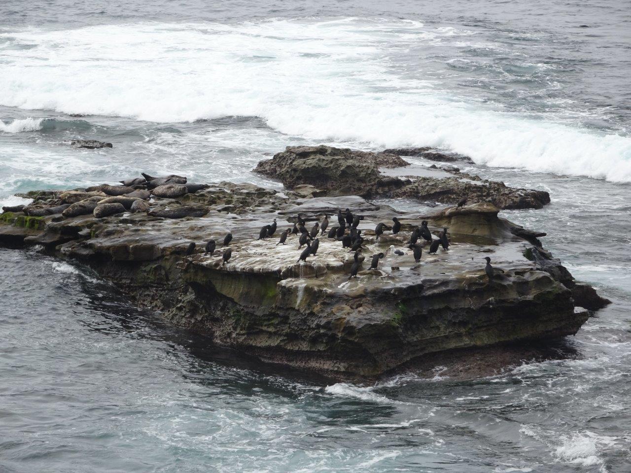
This rock is shared by birds to the right and seals to the left.  


I have seen California sea lions in a lot of places along the west coast, but this is the first time I have seen Harbor Seals.  These guys look like someone took a seal balloon and overinflated it. They are round with no discernible necks.  Also, they do not move well on shore because their legs are very short and they cannot walk on them like sea lions can. 

This species can also be identified by their spots.

This is the cove itself.  The small breakwater protects the seals from the larger waves and makes a good place to have their pups in the spring. 


Good closeup.  Strange how they often hold their tails off the ground. See how short their flippers are?  Not good for walking.  

They also have short faces, whereas sea lions have longer dog-like snouts. This one is on a rock outside of the breakwater and kept getting hit with waves as the tide came in. 


You are allowed to walk on the sand of the cove, but are required to stay back from the seals. I overheard some ladies say that this was really a swimming beach a long time ago, but the seals had ruined it with their poop.  Let's just say it is not a place where you would want to walk barefoot!

Enough with seals.  I spent a good hour plus walking along the oceanfront at LaJolla, then headed back home.


Thursday, October 26, 2017

10/26 Tehachapi, CA, and Loop

Note: I changed the title of my blog slightly because almost no one was getting the John Steinbeck connection--too young, I guess.  My intention was to refer to the last book he wrote, describing his travels across America for a year with his wife's standard poodle, Charley.   

Tehachapi is a town at the top of the Tehachapi pass and is a major route from California to Las Vegas.  A lot of Californians drive past, but few stop, but I think this is a really nice little town for several reasons.  The first is that is has a really nice bakery!  The second is that it has just enough stores and restaurants, but not so many that it has traffic problems.  It also has a glider airport, with an attached campground where you have a great view of gliders taking off.  And, while it is surrounded by really hot deserts, it is a lot cooler up here.  And finally, it has the nearby Tehachapi Loop, which is a a historic railroad loop where trains gain altitude by circling around themselves and going through several tunnels and switchbacks.

The highway into Tehachapi also gains almost 4,000' in altitude and is scenic.  However, there was smoke coming in yesterday, so it was not quite as scenic as it usually is because some mountains are obscured.

So, this morning I headed out for the day to do some exploring and stop at the fantastic bakery.  Loaded up and stuffed some goodies in the freezer for next week.  Yum!

Fun to watch the gliders, but I did not get a chance to take photos of them taking off.

I got directions from the visitor's center and headed south of town to find a good place to take photos of the Tehachapi Loop. Narrow and winding road, but nice view of the highway below.


Here are a couple of plaques describing the construction.  (Please ignore the graffitti.)


Here is what the loop looks like. 


And here comes an Amtrack train!  Click the link for a YouTube video I made: https://youtu.be/1JDnVeAwmaU 

The next train was a regular freight, but unfortunately it was not long enough for it to pass under itself as many do, and I was too lazy to wait longer.  Click in this link for a video of this train:  https://youtu.be/W-oV4RxVrNg


I got on the highway and headed back.  The next few photos should some of the tunnels the trains go through on the way to and after the loop.


Tomorrow I get up early and head for San Diego.


Monday, October 23, 2017

10/23 Hensley Lake Campground

I've been really lazy lately, staying here at one of my favorite campgrounds.  So what makes this one of my favorite places?  

First, it is a pretty place.  From my campsite, I can see the lake and dam, as well as look out on rolling hills.  Most campgrounds are laid out in rows on flat ground and are very boring. This one has some character. 


Also, you may have noticed the lack of campers.  That is the second reason why I like this place.  Today, there are four out of fifty campsites occupied.  That is actually fairly crowded compared to the times when I have been the only camper here. 

The reason?  Mostly, the lake level  has been very low for the past five years, so there is no boating.  The level went up in January and February 2016 after the heavy rains California had, but it is low again because a lot of water has gone to farmers.  It will fill up a bit in the winter and spring. 

There are three boat ramps on this side of the lake.  The one closest to us is unusable right now, but the car is parked on the ramp that is slightly lower.  I am told there is an even lower ramp.


These campsites are behind mine and below it.  No one here today, however.  But up on the hill and to the right of this site, there is someone camped.  Just cannot see them from my site, however. 

Another reason I like this place is that this is a Corps of Engineering campground, and as a senior with a federal pass, I am charged half-price, or only $15 per night for a site with an electric hookup. And the one I am on right now, also has a water spigot.  Corps campgrounds are not only cheap, they are also well-maintained and clean.  No trash on the ground and no crumbling asphalt roads.

These campers in the popup are the only human beings I can see from my campsite. It is so quiet here, I can occasionally hear them talking and hear a cow mooing in the distance.  I used my telephoto lens with this photo, so they are actually farther away than they look. 
Here is a neat trick the maintenance people use at this campground.  Notice that this trash can has a couple of small rocks on it?  Each campsite has a trash can, and last weekend there were seven sites occupied.  If you were collecting trash, you might not know which trash cans had trash in them.  To save time, the maintenance people put a small rock on the lid so that when someone puts trash in, the rock falls off.  So, when they drive around to collect trash every few days, they stop only at trash cans without rocks on them! 

There are a lot of cattle ranches in this hilly area on the east side of the Central Valley in this area northeast of Fresno.  Most have big, fancy entrance gates and huge homes.  Obviously, someone is making a lot of money on steaks!  Farmers in the more level areas just west of here also grow a lot of almonds, pistachios, grapes, and fruit such as peaches. 

I went out grocery shopping today and noticed this house with the grass burned around it.  This is a poor photo, but this is really a huge two-story house.  I suppose putting up with a burned yard is better than worrying about your home being burned down in a grass fire in these dangerous California days.  It will turn green again when it starts raining again in a few weeks. 

  
Here is another photo of the same house.  I can see it on the other side of the lake and you can see the size better.


PS, I drove past this house again as I left the campground today, and I looked at it more carefully.  It is apparently under construction.  I wonder if they burned the grass because they wanted to get rid of the old grasses prior to putting in a lawn??  I also considered that this was just plowed ground or something that was covering the future lawn, but it was not plowed.  For one thing, it was much blacker than the dirt is around here.  And it was clearly burned.  Maybe they did this because no one is living in it yet and no sprinkler system is installed in the yard???  Very strange, anyway.