This campground was a little more tight than Fort Stevens, but the sites were much closer to the ocean. Love hearing the surf at night! The first night, I had one of the full hookup inner sites, shown here.
Then I moved to the only electric and water site along the dunes among the tent sites. I could not see the ocean because of the high dune hill on the left in this photo, but it was a short walk to one of the beach entrances.
Very nice beach. The next two photos were taken at medium tide.
The following photos were taken at an exceptionally low tide.
It looks like this is too deep to wade in, but it is really only maybe a quarter inch deep so easy to walk in without getting your feet wet. I love these very shallow beaches because they are so wide during low tide.
Good surfing waves!
The north end of the beach had a lot of streams and rivulets where the water was draining. I was able to walk on the dry spots for a quite a ways.
One large area looked like a strange moonscape. I assume if I had waited long enough most of these puddles would have drained completely. The sand was really hard so it was very easy to walk here.
Eventually, I got my sandals wet because I had to wade across some puddles in order to get to the sandbar and the surf.
Hardly any shells on this beach, but here is a jelly that I found. It was still alive.
And this is a view from the edge of the surf back to the campground. My motorhome is just behind the dune about in the middle of this photo. Amazingly wide beach!
This is one of the best museums I have visited. It focuses on the lifesaving, navigation, and local fishing.
Astoria, I finally discovered, was named after John Jacob Astor, who had a fur trapping business here. It is a nice little town with a very nice riverfront, and of course this maritime museum.
There are several Coast Guard boats in the museum. This one is outside.
I had to stop and look through the window at this one. What an angle! It is trying to impress upon visitors how rough the sea can be when I lifesaving boat goes out to rescue someone.
This shows all the ships which have wrecked in the Columbia river and the ocean at the opening or the "bar."
And here is the lifesaving boat I saw through the window. All the "people" are tethered with long straps to prevent them from falling overboard.
This shows "the bar" or the sandbar that forms at the opening of the river. At this point, the river water meets the ocean currents and creates huge waves. There are river pilots, but there are also specialized "bar" pilots.
More Coast Guard boats.
And this is a fishing boat.
This sign explains about a small Japanese boat found on the beach.
Admission also includes a tour of the lightship Columbia. Before satellite navigation and radar, this ship acted as a lighthouse 5 miles out to sea beyond the mouth of the river.
There is a very nice bike path along the river and a $1 trolley you can take. I was impressed that the local Safeway store had RV parking, which is where I was when I took this opportunity to take a photo of the bike path and trolley.
And of course, I could not ignore the constantly barking sea lions nearby. Don't these guys ever get tired of making noise? Or do they take turns??
Lewis and Clark built a small "fort" near Astoria, Oregon, at the mouth of the Columbia River for the winter before they headed back east. This is now a national park, with a reconstruction of the fort based on notes made by the explorers.
This is a reconstruction of a native canoe, similar to one the explorers used in the last part of their journey west.
This is the reconstructed "fort." Basically, it had two rooms for the men who accompanied Lewis and Clark, one for Lewis and Clark, and one for Sacajawea and her husband.
The fireplaces were pretty primitive. No rocks, so there were made of wood with mud plastered on the back.
This is looking up one of the chimneys.
Fort Stevens was built during the Civil War and used heavily during WWII to protect the Columbia River from Japanese submarines. In fact, 17 shells were fired onto the fort, but no serious damage was done. All that is left of the fort are the foundations of buildings and the cement gun batteries.
There is a small museum and gift shop run by camper-volunteers. These people volunteer as camp hosts and tour guides who also run the museum. In exchange, they get a free campsite for a couple of months commitment. I enjoyed chatting with them because they also are older retirees who live in motorhomes or fifth-wheel trailers for part or most of the year. Most of this group had homes in Oregon, but enjoy the activity and friendship with fellow volunteers so they volunteer each year for several months at various parks. One couple are in the campsite next to mine, so I had met them yesterday.
There is a walking tour of the batteries, but I chose the guided tour on the old truck. It turned out to be considerably bumpier than I had planned on.
Fort Stevens State Park is on the far northwestern tip of Oregon where the Columbia River meets the Pacific Ocean. It is also the largest state park in Oregon and has over 300 campsites in big trees.
I headed to the beach today, about a mile from my campsite, to see the wreck on the beach.
As the sign says, the ship was an iron-hulled sailing ship that wrecked in 1909.
This is looking south to Cape Lookout.
Rough water would make good surfing.
Down at the far north tip of the spit of land that makes up the state park is the mouth of the Columbia River and some wetlands.
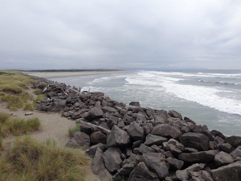
Nice observation tower. The South Jetty is a long strip of large rocks that protects the river and the shipping channel.
This is the view south along the ocean coast from the tower.
And this is the view across the river to Washington. You can barely see white Cape Disappointment lighthouse in the distance.
Lots to do at this state park. Tomorrow I visit the old fort.