Wednesday, November 4, 2020

11/3 Drive to Valley of Fire State Park

Valley of Fire is about 60 miles northeast of Las Vegas and is one of my favorite places.  I have been here several times and have enjoyed the bighorn sheep that sometimes wander through and the thousands of pictographs in the area. 

The campground is tucked away in an area where it is circled about 3/4s of the way with deep red rocks.  And the campground is relatively new with electric and water at several sites.  The only problem I have is that all Nevada state parks are first-come, first-served, which means that you need to get up very early to get here in the morning to make sure you can get a spot.  Plus, I like the spots near the edge of the campground because they have better cell service.  

So, I got up this morning very, very early for me, and unhooked and drove 80 miles to make it here by 10 am.  The drive starts along the south shore of Lake Mead and goes along the west side of the lake on a very long curving and scenic road through a lot of mountains. 

If I had had time, I would have liked to stop at the dam and even the visitor center, but i have been there before and just no time this morning.  Anyway, here is Lake Mead with not a lot of water in it.

Talk about a bathtub ring.  This lake is as bad as Lake Powell! 


You could get a geology lesson from this area! 

After about 60 miles, you start to see red rock.


Just before you get to the state park entrance, you see the northern tip of Lake Mead. 


You can see why they call this area Valley of Fire.  The rocks are red because of iron ore in them.


Inside the park now.  Very pretty.

This is inside the campground.  


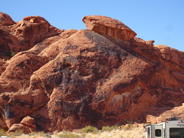
I know people who will not stay here because of two rocks that look like they could easily be pushed over by a couple of boy scout leaders! Thiis is the front view of one large rock, about the size of a small house.

 
And an even scarier side view of the larger rock. 


 This is a smaller rock, maybe only the size of a car. 


And a closeup of the smaller rock. 

By the time I arrived here, there were only three empty sites.  I got my favorite handicap site where I had stayed before.  I chose it because it was close to the valley and better cell service.  Last time I was here in March, 2019, there was only one regular and one handicap site and the camp host insisted I take this one because she said the handicap sites don't get used, and they have several.  Other good news is that the Verizon service is MUCH better here now, and they even have internet access for a fee, but of course I have my own mobile hotspots. 

I'll be here for five nights and then will go back to Lake Mead and stay at the no hookup Boulder Beach.  It has nice paved sites, and also is right on the paved bike path that I can take almost to the dam. 

By the way, if you come to the Lake Mead area and think you know your way around, forget it!  In the last 18 months since I last visited, they opened a new stretch of freeway that takes you way out of your way if you miss the new exits.  I learned that lesson last week when I went to the Boulder City post office, so this trip I managed to get off at one of the new exits which took me where I had wanted to go last week! 


Tuesday, November 3, 2020

11/1 More Willow Beach Marina & Campground

 These are some more photos of the Willow Beach Campground, the marina, and the fish hatchery.  First some desert bunnies and Gambels quail. There must be a couple of hundred bunnies running around the campground, mostly because all the plants are drip irrigated and thus provide lots of hiding places and food.  Doesn't this guy look like he should be chocolate?  

This one is typical in size--about 8" tall, including the ears, so they are pretty small, but they looked pretty healthy.


I love these little quail, but most of my pictures are slightly blurred because they do not hold still.  The rabbits are much more cooperative. The ones with the smaller topknots and more muted color are females.  The one in the background in this photo is a male.


Looking up the hill at the ranger's homes.


My second campsite.  I had to move around because they had double-booked my original site.

There are lots of big clumps of grasses and other shrubbery.  These provide food for the rabbits and quail and also good hiding places.

Next, I headed down the hill to the marina and visitor center.  The campground road goes over this wash which provides a place for rain to be guided out of the way of the campground.  

You will notice that the campground is fairly new, as are all of the buildings in this recreation area.  About 30 years ago, there was a federal and a private campground in the area east of the current campground.  There was a huge flood that not only destroyed both campgrounds, but also the visitor center, and all of the ranger's facilities.  It is hard to imagine enough rain in this very dry desert area to cause floods, but this wash carries water from several square miles of land as far up as the freeway, which is four miles away. 

The road to and from the campground actually runs right down the edge of the wash.  It would be interesting in another flood, as there is no other road to get out of here.

This photo is taken from the roadway, about halfway down the wash to the marina and the Black Canyon of the Colorado River.  It is 12 miles south of Hoover Dam and Lake Mead.  Actually, they considered building Hoover Dam in this area, but luckily changed their mind.  It is strange land, but beautiful.  You can take a boat or kayak all the way down to Lake Mohave from here. 

The land on the other side of the river is a wilderness area and very hard to access.

This photo is taken from the edge of the large marina parking lot and looks up the road to the campground.  It has a stone wall that is supposed to protect the parking lot and marina from flooding.  Weird to have to worry about flooding in such a dry area, isn't it?

View looking north up the Colorado River.  You may bring your own power boat or rent one at the marina, but no motors are allowed on Sundays and Mondays. 

A closer view of the fishery.


And pictures of some of the fish they raise.

All of these buildings and the areas around and between them are covered with netting to prevent feathered thieves from stealing fish.  It is also fenced to prevent four-footed, furry thieves.


And these coolers contain tiny baby fish that have just hatched.  They stay here until they are big enough to go in the larger pens.

These are all rental boats in the marina.

You can tell by the steepness of the walkway how low the water level is.

And back up the campground roadway that goes through the wash. 


Saturday, October 31, 2020

10/31 Willow Beach & Desert Big Horn Sheep

 Willow Beach is a secret of sorts.  At least it is not listed on the two big reservation sites:  Reserve America and Recreation.gov.  It is my go-to place when I am looking for a quiet scenic place and getting away from family crowds.  There are a few families, but mostly I manage to come here when it is slightly off-season.  

One of the disadvantages is that is is down a 4 mile long road that is paved but really needs to be replaced.  Also, while there are a couple of fairly new gas stations about a dozen miles away, basically, it is 25 miles from grocery stores.  Location?  It is on the Arizona side of the Colorado River and about 13 miles south of Hoover Dam.  There is a big marina with a lot of rental boats, a visitor center, and a fishery, but I will take some photos of those tomorrow.  

Another disadvantage is that there is absolutely NO cell service here.  Luckily, there is pretty good internet service, which is what I am using right now.  The campground has showers and a little laundry room, plus all of the camping sites except the tent sites are full hookup and paved, which means I have electric, water, and sewer.  It is very open so good satellite service also.  And sites are very spread apart so you have some privacy.  Oh, and because it is a federal site, seniors get their sites for half price, which is a real bargain.  I'll also take some photos tomorrow of all of the little desert bunnies and the Gambel Quail that run around constantly, cheeping nonstop and worrying about getting lost from their flock!  Funny birds. 

Here is the road, headed north from Kingman, AZ.  A lot of Arizona is dry, but this area is REALLY dry!  But it has some beauty to it, anyway, because of the shapes and colors.  In the next few photos, the Colorado River is off to the left a couple of miles and down in a canyon, but it is very hard to access it, except at the Willow Beach Marina site.


Amazing how the color changes in places. 
 
This is an animal bridge.  It is fenced so that animals who might be trying to cross the roadway are guided safely to this and a couple of other animal bridges.
 

I have never seen a big horn sheep or other animal on the bridges, but I suspect they are heavily used at night.


There is not much of a sign to let you know this is the right road.  And it really is not a lake, just a slightly wider place in the river.  

This is part of Lake Mead National Recreation Area, so there is a fee to get in,  unless of course, you are a senior with a pass, like me.  When I first started coming here about six years ago, the entrance booth was closed.

This is the road to the river.  It really needs to be replaced, and I was told a year ago that money had been allocated, but they have to build a completely new road because this one "goes down the wrong canyon," as I was told.  What that really means is that when it does rain, all the rain from a very large area goes down the canyon and wipes out part of the road.  They keep heavy equipment to repair the road each time.  So, the plans are to build a new road that does not go through this particular canyon so it won't get wiped out so often.


I really intended to take some photos of the river and the marina, but will do that tomorrow in a separate posting.  Today, I wanted to show some photos I took of some desert bighorn sheep that came by today.  This photo is taken from my RV site, but the sheep were on the hill near the last RV on the right.  (I found out that desert bighorn sheep are slightly smaller and lighter colored than Rocky Mountain sheep.)

A few of the sheep were on the ridge.  I believe these two are rams, based on their horns being thicker.  Ewes have thinner and shorter horns. 

I am pretty sure the one in the front on the left is a ram, but it is hard to tell because they all have horns.  Rams have bigger horns and, as the lady on Life Below Zero calls them, "dangly bits." Can't see the dangly bits, but his horns are definitely thicker and longer.


All the ones below are ewes.

These two rams definitely have "dangly bits."  They also have thicker and longer horns and are bigger in body size overall, so they are probably fully adults.

The one on the far left is a ram.  Overall, I saw about 12-15 big horns, which is a good-sized herd. 

My campsite. 

The campground, looking down toward the river, which is about a thousand feet away.

By the way, every single patch of grass or bush in the campground has its own drip irrigation system.  The greenery encourages a large desert bunny population and several flocks of Gambel quail, but more on that tomorrow.